
- elevation 913 m (2,995 ft) Basin area 37 km² | Length 21 km | |
 | ||
- location Sapporo, Hokkaidō, Japan | ||
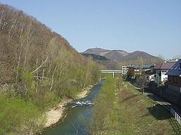
Makomanai River (真駒内川, Makomanai-gawa) is a tributary of the Toyohira River in Sapporo, Hokkaidō, Japan. It has a length of 21 kilometres (13 mi) and has a watershed of 37 square kilometres (14 sq mi).
Flowing from Bankei Pond (万計沼, Bankei Numa) in the mountains, the Makomanai River's upper course is called Bankei River (万計沢川, Bankeisawa-gawa), too. Its middle course flows through a narrow valley about 200 metres (660 ft) wide in the Tokiwa (常盤) area. Running north, it merges with the Toyohira River at Makomanai area. The Toyohira River flows through the Sapporo city's center. Makomanai means rear river in the Ainu language.
Edwin Dun, an Oyatoi gaikokujin, began development of Makomanai in the 1870s with a pioneer stock farm. The valley of Tokiwa remained undeveloped for a long time. Flood control projects were begun in the later half of 20th century; straightening the river course in the 1960s. Now a residential zone exists along the northern half of Tokiwa along National Route 453. Houses cover the surrounding hilltops around Makomanai. At the confluence with the Toyohira River is Makomanai Park. Cherry salmon migrate to and spawn in the park every year.