
Year first lit 1915 (current) Markings / pattern white tower Focal height 64 m Range 11,112 m Year first constructed 1899 (first) | Deactivated 1915 (first) Light source solar power Height 22 m Local time Friday 11:38 PM | |
 | ||
Construction masonry tower (first)
reinforced concrete (current) Tower shape conical frustum tower (first)
square pyramidal tower with balcony and light Weather 21°C, Wind NE at 13 km/h, 96% Humidity | ||
Māhukona is a former settlement on the island of Hawaiʻi. The extinct submerged volcano Māhukona, off shore and to the south, is named for this area. The settlement was once the terminus of the Hawaiian Railroad.
Contents
Map of M%C4%81hukona, Hawaii 96743, USA
History
Māhukona was a traditional land division (ahupuaʻa) that extended from a bay to the slopes of Kohala mountain. Much was owned by Princess Ruth Keʻelikōlani at one time. The name means "false harbor" in the Hawaiian language. Lapakahi State Historical Park is just to the south. The harbor is located at 20°11′1″N 155°54′2″W just off of Akoni Pule Highway, Hawaii Route 270.
While Samuel Garner Wilder was minister of the interior, he secured a charter for a railroad company in 1880. The first sugarcane plantation in the Kohala district was started by Elias Bond in 1863, but transportation proved difficult. Wilder's idea was to transport sugarcane from sugarcane plantations on the wet windward side of Kohala to Māhukona where ships could land. Wilder already ran a steamship company, so built a pier at the Māhukona harbor. Samuel Parker planned a railroad from the east coast to the port of Hilo, but was unable to fund the project. Work was begun in 1881, the first track opened in 1882, and by 1883 had reached about 20 miles (32 km) to the plantation at Niuliʻi, 20°13′23″N 155°44′48″W. There it met the barrier of Pololu Valley.
Wilder named the first locomotive Kinau, after his wife. He had plans to extend his railroad to Hilo, but that would not happen until after his death, by the Hawaii Consolidated Railway. The two would never be connected as dreamed by Wilder. In 1897 the railroad reincorporated as the Hawaii Railway Company, Ltd., and was bought out by the sugar companies in 1899.
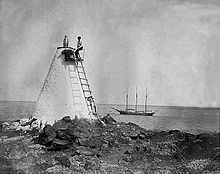
A sugar mill was built on the north side of the bay, and its remains still stand. A larger wharf was built in 1911 by the Territory of Hawaii that was immediately destroyed by a storm, and rebuilt again. In 1913 it was the fourth busiest port in the islands, but only had 13 vessels enter. The first lighthouse was built in 1889 just to the south of the bay. In 1915 it was replaced by a concrete pyramid 22 feet (6.7 m) tall. By 1937, the Kohala Sugar Company had considated all the business into the mill at Māhukona, and became Mahukona Terminals Ltd. In 1941 the port was forced to close for World War II. On October 29, 1945 the railroad shut down.
The town which once consisted of about 40 families, was abandoned in the 1950s. In 1956 the harbor was closed. The bay is now the site of a park of Hawaii County. Although called Māhukona Beach Park, the shoreline is rocky and there is no sandy beach. Fishing, snorkeling, picnic areas, and camping are available.
In the 1990s a developer obtained permits to build a golf course and resort in the area. The land-holding company was renamed the Kohala Preserve Conservation Trust, LLC, but encountered opposition from residents in the area. A historic song about Māhukona, translated as "sugar boiler" was recently recorded.