
County Csongrád Rank Village Area 48.02 km² Local time Saturday 5:18 AM Area code 62 | Subregion Makói Time zone CET (UTC+1) Population 1,538 (1 Jan 2008) Postal code 6932 KSH code 05962 | |
 | ||
Weather 7°C, Wind SE at 10 km/h, 66% Humidity | ||
Magyarcsanád (Romanian: Cenadul Unguresc; Serbian: Чaнaд / Čanad) a multi-ethnic village located in Csongrád (county), southeast Hungary near the Mureş River (Hungarian: Maros). The Maros is a border-river here between northern Hungary and southern Romania.
Map of Magyarcsan%C3%A1d, 6932 Hungary
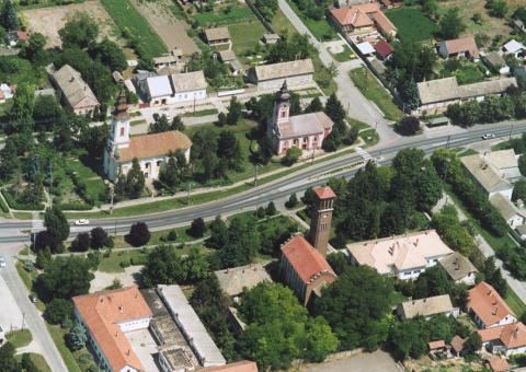
The population is mainly Hungarian, but many Romanians, Serbians and Romani people are also living here. Magyarcsanád has four churches: a Romanian Orthodox, a Serbian Orthodox, a Calvinist and a Roman Catholic.
The village has an own outskirt called Bökény directly near the Maros. Here is a tumulus (Hungarian: kunhalom) in which archeological artifacts were found.
Magyarcsanád has a partner-settlement Comloşu Mare (Hungarian: Nagykomlós) in Timiş County (Hungarian: Temes).
An old stone cross was erected near Magyarcsanád in the Middle Ages. The cross still stands. There is a small isle called in Hungarian "Senki szigete" (in English: Nobody's Isle) some kilometers eastward from Magyarcsanád on the border river Mureş. The isle is inhabited by Phalacrocoracidae (Phalacrocorax carbo).