
Country Philippines Barangays Area 755.4 km² Local time Saturday 11:40 AM | Incorporated June 22, 1963 Demonym(s) Magpeteños Elevation 300 m Province Cotabato | |
 | ||
Region SOCCSKSARGEN (Region XII) District 2nd District of Cotabato Weather 29°C, Wind NE at 11 km/h, 71% Humidity Neighborhoods Basak, Bagumbayan, Datu Celo, Alibayan, Temporan, Balite, Mahongkog | ||
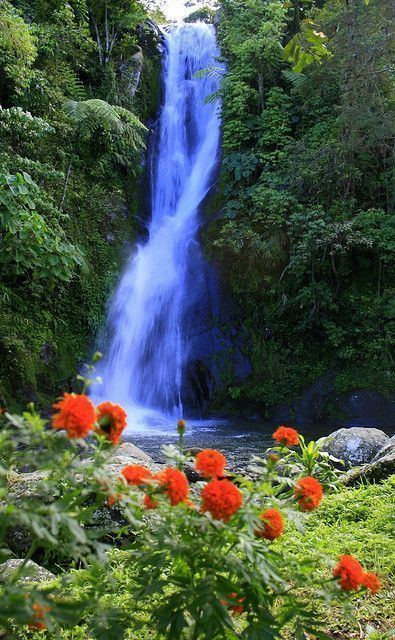
Bobong falls adventure magpet cotabato via ilomavis kidapawan city
Magpet is a first class municipality in the province of Cotabato, Philippines. According to the 2015 census, it has a population of 49,201 people.
Contents
- Bobong falls adventure magpet cotabato via ilomavis kidapawan city
- Map of Magpet Cotabato Philippines
- Geography
- Barangays
- History
- Demographics
- Tourist attractions
- References
Map of Magpet, Cotabato, Philippines
Geography
Magpet is located in the eastern part of Cotabato province and in the foothills of Mt Apo with generally sloping and mountainous terrain. It is bordered in the south by Kidapawan City and on the north by the Municipality of Arakan.
Barangays
Magpet is politically subdivided into 32 barangays.
History
Magpet derived its name from the word “malotpot” which means “a place where people gather in fellowship to partake of their packed lunch wrapped in banana leaves”.
An anonymous lexicographer inadvertently shortened the word “Linoppot” to “Maupot”. Much later and further spelled into “MAGPET” by a certain forester in his survey report. Consequently, the word “Magpet” stuck not only to mean the place but also the stream of the cool, fresh and clean water. By the present connotation, Magpet means “the verdant lands of countless waters”.
The life of the early year’s settlers and inhabitants of Magpet was a tale of survival and fortitude. Their lives were always in danger. Bloodthirsty malarial mosquito’s attacked them. Grandparents often told their grandchildren the stories “about eating their meals inside the mosquito nets” because “mosquitoes were as big as bees”.
Yet, all the hardships and suffering, and even death of the early settlers only served to strengthen their decision to stay and utilize the vast natural resources of Magpet. The land was very fertile and varieties of fishes were found in the rivers and streams, and on the woodlands, wild pigs, deer and birds are plentiful. Food was not a problem during that period, but rather, marketing of production surplus and purchase of basic commodities. They traveled for days and weeks in order to sell their crops to the nearest trading centers and they needed salt, sugar, matches and soap for daily needs.
Demographics
In the 2015 census, the population of Magpet, Cotabato, was 49,201 people, with a density of 65 inhabitants per square kilometre or 170 inhabitants per square mile.