
PIN 686 513 | Time zone IST (UTC+5:30) Vehicle registration KL-34 | |
 | ||
Madukka is a small village surrounded by forest located in the district of Kottayam, Kerala.
Contents
- Map of Madukka Kerala
- Geography
- Transport
- Economy
- Celebrities
- Places of worship
- Cultural centers
- References
Map of Madukka, Kerala
Geography
Madukka is a small village surrounded by dense forest and with hilly terrain.
Transport
The village is well accessed by road transportation and public transportation facilities are available to major towns like Kottayam and Changanacherry. The nearest railway station is Kottayam Railway Station. The nearest airport is Cochin International Airport.
From Kottayam: Kottayam-Pampady-Ponkunnam-Kanjirappally-Mundakkayam-MadukkaFrom Changanacherry: Changanacherry-Karukachal-Ponkunnam-Kanjirappally-Mundakkayam-MadukkaEconomy
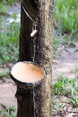
The main source of economy depend on cultivation and farming. The main crops are latex, pepper and seasonal fruits like banana.
Celebrities
Places of worship
Puthenpally juma masjid, Shree shastha Temple and St. Mathew's church are the important worship centres in Madukka. The population is predominately Christian, Hindu, Muslim and Malayarayans.
Cultural centers
References
Madukka Wikipedia(Text) CC BY-SA