
Length 21 km (13 mi) Northeast end Harbour Road | Ring road around Mackay | |
 | ||
Type Highway (Under construction) South end Bruce Highway (National Highway A1), Bakers Creek Major settlements Bakers Creek, Ooralea | ||
Bruce highway and mackay ring road promise exposed as a sham
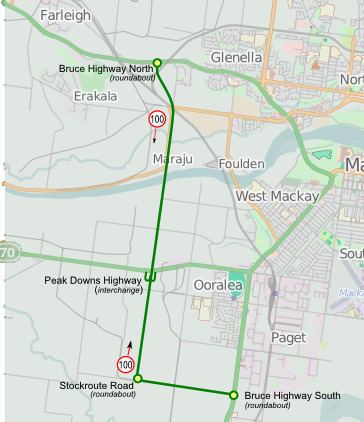
The Mackay Ring Road is a proposed bypass route of Mackay. The proposed road is 21 km long and will be built in 3 stages.
Contents
- Bruce highway and mackay ring road promise exposed as a sham
- Labor refuses to fast track mackay ring road jobs
- Milestones
- Future Timeline
- References
Stage 1 is 11.34 km in length and will connect the Bruce Highway to the south of Mackay (at Stockroute Road) with the Bruce Highway to the north of Mackay (near Bald Hill Road). It will involve a new bridge over the Pioneer River and an interchange with the Peak Downs Highway. It aims to provide a bypass of Mackay for Bruce Highway traffic that is immune to flooding and free of signalised intersections. Stage 1 of the project is expected to cost $540 million, 80% of the funding is from the Commonwealth and the remaining 20% from Queensland.
Stage 2 is 8.2 km in length. It will connect Stage 1 near the Bruce Highway at Glenella to Harbour Road at Mackay Harbour. The route will follow the Mackay Harbour Railway (Port Rail Line).
Stage 3 is 1.4 km in length. An additional connection from Stage 2 to the Port and Slade Point Road.