
 | ||
Similar Macizo de Teno, Teide, Mirador Cruz Del Carmen, Roques de Anaga, Playa de Las Teresitas | ||
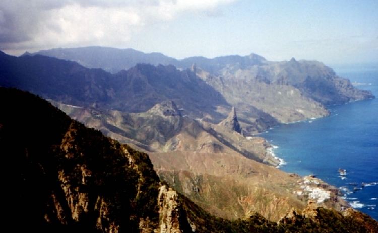
Macizo de anaga
Macizo de Anaga is a mountain range in the northeastern part of the island of Tenerife in the Canary Islands. The highest point is 1,024 m (Cruz de Taborno). It stretches from the Punta de Anaga in the northeast to Cruz del Carmen in the southwest. Anaga features the mountain peaks of Bichuelo, Anambro, Chinobre, Pico Limante, Cruz de Taborno and Cruz del Carmen. The mountains were formed by a volcanic eruption about 7 to 9 million years ago making it the oldest part of the island. Since 1987 it has been protected as a "natural park", reclassified as "rural park" in 1994. Since 2015 it is also Biosphere Reserve and is the place that has the largest number of endemic species in Europe.
Contents
- Macizo de anaga
- Map of Macizo de Anaga 38139 Las Casas de la Cumbre Santa Cruz de Tenerife Spain
- Alexander von humboldt en el macizo de anaga en la isla de tenerife
- References
Map of Macizo de Anaga, 38139 Las Casas de la Cumbre, Santa Cruz de Tenerife, Spain
It is a remote and wild area characterized by humid forests, such as laurisilva. Native plant species include Ceropegia dichotoma, Ceropegia fusca and Echium virescens. The Macizo de Anaga is also rich in archaeological finds, among which is the Mummy of San Andrés belonging to the ancient Guanche. The main villages in the Macizo de Anaga are San Andrés, Taganana and Igueste de San Andrés. A place in the mountains known as El Bailadero is believed to have been a place where witches were practicing witchcraft and dancing around a bonfire.