
 | ||
Similar Yim Tin Tsai, Sharp Island, Tung Ping Chau, Tolo Harbour, Ap Chau | ||
Geopark ma shi chau
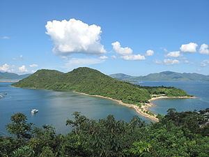
Ma Shi Chau (Chinese: 馬屎洲 Cantonese: ma5 si2 zau1, literally meaning "horse excrement island") is an island of Hong Kong, under the administration of Tai Po District. It is located in Tolo Harbour in the northeast New Territories (near Sam Mun Tsai). It is connected with another island, Yim Tin Tsai, by a narrow strip of land that is only accessible when the tide is low.
Contents
- Geopark ma shi chau
- Map of Ma Shi Chau Hong Kong
- Dji phantom 4 over ma shi chau 4k
- GeographyEdit
- BusEdit
- MinibusEdit
- References
Map of Ma Shi Chau, Hong Kong
Dji phantom 4 over ma shi chau 4k
GeographyEdit
Ma Shi Chau has an area of 0.61 km2. It is part of the Ma Shi Chau Special Area, as it exhibits tombolo and tide features rarely seen in Hong Kong. It is the largest island of the four in the Special Area, the others being Yeung Chau, Centre Island and an unnamed island near Yim Tin Tsai.
It has sedimentary rock dating back to the Permian period that is protected by its Special Area status.