
Touristroutes: Lake Huron Circle Tour Constructed 1920 | Length 70.36 km | |
 | ||
Existed: c. July 1, 1919 – present Counties | ||
M-48 is an east–west state trunkline highway in the Upper Peninsula (UP) of the US state of Michigan. It connects Rudyard with Pickford and continues to the far eastern end of the UP. The highway runs for 43.723 miles (70.365 km) through rural parts of Chippewa County, including along the county line with Mackinac County. Between 580 and 1,800 vehicles a day use the roadway daily.
Contents
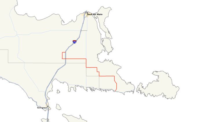
Map of M-48, Michigan, USA
The highway was designated by 1919 along a route that ran much farther west in the UP. Within its first decade, M-48 was extended to end at a point north of Newberry. Since the 1960s, it has had its current configuration. A section of roadway that was previously used as part of the western end of the highway was redesignated as a section H-40 in the 1970s.
Route description
M-48 currently starts at an interchange with I-75 in the Rudyard area. The highway runs west from the interchange into Rudyard where it turns south, running concurrently with county road H-63. M-48 turns eastward south of town along 22 Mile Road through fields. At Meridian Road, M-48 turns south along M-129 through the community of Pickford. South of town, M-48/M-129 runs long the Chippewa–Mackinac county line and crosses the Munuscong River. M-48 turns east at 26 Mile Road into Chippewa County. The highway zig-zags through rural areas in the southeast of the county. It follows Hanna and 28 Mile roads to Stalwart. In that community, M-48 runs south on Reynolds Road to a corner on the Chippewa–Mackinac county line where the highway turns back east toward the Goetzville area running through the Lake Superior State Forest. After one last north–south segment, M-48 terminates at a junction with M-134 west of DeTour Village near Albany Harbor.
The Michigan Department of Transportation (MDOT) maintains M-48 like all other parts of the state trunkline highway system under its jurisdiction. As a part of these responsibilities, the department tracks the volume of traffic along its roads using a metric called average annual daily traffic (AADT). This measurement is a calculation of the average traffic levels for a roadway segment on any average day of the year. In 2009, MDOT figured that between 580 and 1,800 vehicles a day used sections of M-48. In addition, the department has added the portion of M-48 between the northern M-129 junction and M-134 to the Lake Huron Circle Tour, a scenic drive that loops around the lake. No part of the highway has been added to the National Highway System, a network of roads important to the country's economy, defense, and mobility.
History
On July 1, 1919, M-48 ran from Rexton to Trout Lake and eastward on to Rudyard. The highway continued to Goetzville and ran to DeTour Village at the eastern tip of the UP. By 1927, the western end was moved to a point north of Newberry. M-48 was extended along US Highway 2 (US 2) to Garnet. From there, M-48 ran north to M-28 east of Newberry. It turned west along M-28 into Newberry and then north to Four Mile Corner. In the mid-1930s, M-28's routing through the Newberry area was shifted. As a result of this shift, the section of M-28/M-48 in downtown was renumbered M-28A/M-48. In the early 1940s, US 2 was moved to a new routing along the Lake Michigan shoreline. In the process, the US 2/M-48 concurrency was eliminated. By the same time, M-48 was truncated when M-134 was designated east to the DeTour area. By the end of the decade, M-48 was truncated and rerouted on its western end, replacing the contemporary M-117 south of Rexton to US 2 in Epoufette. All of M-48 west of US 2 was turned over to local jurisdiction and removed from the state highway system, save a section made part of M-123 in late 1960 or early 1961. A few years later, M-48 was extended along a former section of US 2 into Rudyard to connect to the newly opened I-75/US 2 freeway in 1963. After October 1970, the former M-48 west of the current highway was designated as a part of the County-Designated Highway System.