
Existed: 1958 (1958) – present Length 7.842 km | ||
 | ||
County | ||
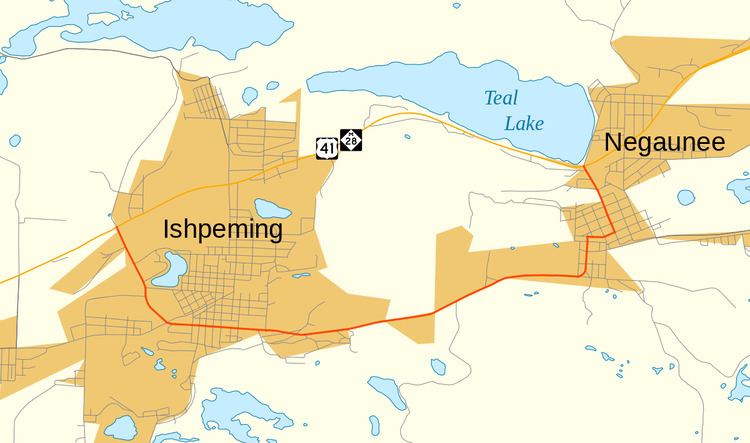
Business M-28 (Bus. M-28) is a state trunkline highway serving as a business route that runs for 4.841 miles (7.791 km) through the downtown districts of Ishpeming and Negaunee in the US state of Michigan. The trunkline provides a marked route for traffic diverting from U.S. Highway 41 (US 41) and M-28 through the two historic iron-mining communities. It is one of three business loops for M-numbered highways in the state of Michigan. There have previously been two other Bus. M-28 designations for highways in Newberry and Marquette.
Contents
- Map of M 28BUS Michigan USA
- Route description
- Ishpeming
- Negaunee
- Traffic counts
- History
- Major intersections
- References
Map of M-28BUS, Michigan, USA
The trunkline was originally a section of US 41/M-28 and M-35. Before the 1930s, the main highways ran through the two downtown areas when US 41/M-28 was relocated to run near Teal Lake. The former routing had various names over the years. It was designated as an alternate route of the main highways, using both the US 41A/M-28A and Alt. US 41/ALT M-28 designations before it was designated as Bus. M-28 in 1958. M-35 continued to run through downtown Negaunee along a section of the highway until the 1960s. A rerouting in 1999 moved the trunkline designation along Lakeshore Drive in Ishpeming, and a streetscape project rebuilt the road in Negaunee in 2005.
Route description
There are currently three business routes in the state of Michigan derived from M-numbered highways. The other two are in Hillman and Niles for M-32 and M-60 respectively. In the past, two other business routes for M-28 existed in Newberry and Marquette, but they have since been retired. The extant Bus. M-28 designation remains for the loop through Ishpeming and Negaunee.
Ishpeming
Bus. M-28 begins at a signalized intersection on US 41/M-28 with Lakeshore Drive in the city of Ishpeming. The trunkline runs south along Lakeshore Drive under the tracks of the Lake Superior and Ishpeming Railroad (LS&I) and southeasterly towards Lake Bancroft. South of the lake, Bus. M-28 turns east on Division Street. Traffic along the highway here can view the towers of the Cliffs Shaft Mine Museum; the museum is dedicated to telling the story of underground iron ore mining in the region.
Division Street carries the Bus. M-28 designation into the central business district of Ishpeming, where it runs past local businesses, Ishpeming High School and the original Ishpeming City Hall. On the east side of downtown, both the central machine shops and the research labs for Cleveland-Cliffs Iron Company are located on Division Street. Continuing east, the trunkline follows Ready Street over hills and through a residential area to the Ishpeming–Negaunee city line.
Negaunee
In Negaunee, the routing uses a street named County Road east from the city line. County Road passes Jackson Park, location of the first iron ore discovery in the area. The iron mined from the region supplied half of the nation's supply between 1850 and 1900. South of downtown Negaunee, Bus. M-28 turns north along the west fork of Silver Street. The street runs north under an overpass that carries Rail Street, so named because it was once a rail line into downtown Negaunee. The trunkline turns east on Jackson Street, running next to the Negaunee City Hall, which was built in 1914–15 at a time when the city's population was increasing and iron production was peaking. The building still houses the city's offices, police station and library.
The business loop follows Jackson Street east to Division Street, where the street curves slightly and becomes Main Street. Bus. M-28 follows Main Street one block to the intersection with Teal Lake Avenue. Turning north, the trunkline follows Teal Lake Avenue through residential areas of town past the Negaunee Middle School and up over a hill. On the opposite side of the hill next to Teal Lake Bluff, the business loop intersects Arch Street, which carries traffic to Negaunee High School to the west or the football field complex to the east. Negaunee High School was the site of the former Mather B Mine Complex. The administration building for the mine was converted to its present educational use in 1986. Bus. M-28 continues along Teal Lake Avenue past the football field and under the LS&I tracks where it ends at another signalized intersection with US 41/M-28 by Teal Lake. The total length of Bus. M-28 is 4.873 miles (7.842 km).
Traffic counts
The Michigan Department of Transportation (MDOT) publishes traffic data for the highways it maintains. On Lakeshore Drive in Ishpeming, MDOT stated that 5,857 vehicles on average used the roadway daily in 2014. Along Division Street, traffic drops to 4,044 vehicles before dropping further to 1,617 vehicles along the section on Silver Street in Negaunee. Traffic increases along Jackson and Main streets to 4,340 vehicles on an average day. Traffic is heaviest along Teal Lake Avenue, at 7,521 vehicles.
History
The state highway system was created on May 13, 1913, with the passage of the State Reward Trunk Line Highway Act. The state originally signposted these highways by July 1, 1919, and the roadways that make up Bus. M-28 were originally a portion of M-15. Later when the United States Numbered Highway System was created on November 11, 1926, the highway was redesignated as a part of US 41 and part of M-28. The main highway was moved with the construction of a northerly bypass of Ishpeming and Negaunee in 1937. The business loop was not designated Bus. M-28 permanently and marked on state maps until 1958. It was designated US 41A/M-28A before being redesignated ALT US 41/ALT M-28. or Bus. US 41/Bus. M-28. This dual designation later was mirrored by the other Marquette County business route, Bus. US 41. Occasionally, more recent maps use this older numbering to label the highway.
When M-35 was routed through downtown Negaunee, it joined Bus. M-28 northward from the east fork of Silver Street on to US 41/M-28. This routing was moved to bypass the city in 1964 when iron ore mining activity destabilized a portion of the M-35 routing southeast of town. From this point on, Bus. M-28 has not shared its routing with any other state trunklines.
In 1969, the Michigan Department of State Highways petitioned the American Association of State Highway Officials (AASHO) to approve a Bus. US 41 designation for the trunkline. Action on the request was deferred by AASHTO's U.S. Route Numbering Subcommittee, and then denied the following year. The western end of Bus. M-28 was rerouted on June 4, 1999, when the City of Ishpeming petitioned MDOT to reroute the highway along Lakeshore Drive to US 41/M-28. Previously, it ran along Greenwood Street and North Lake Road and met US 41/M-28 in the West Ishpeming neighborhood of Ishpeming Township.
MDOT in a partnership with the City of Negaunee upgraded Teal Lake Avenue between Arch and Rock streets in a streetscaping project to provide a "pedestrian refuge area". This work entailed reconstruction of the retaining wall, curbing and gutters in 2005. Arch Street is the access to Negaunee High School, and this section of Bus. M-28 is near the athletic field complex in Negaunee. The project budgeted $120,200 with $24,200 from the City of Negaunee (equivalent to $151,500 and $30,500 respectively in 2015).
Major intersections
The following table lists Bus. M-28's major intersections with the primary Marquette County Roads. The entire highway is in Marquette County.