
Elevation 318 m Local time Thursday 8:57 PM | Postal code 569 41 to 571 01 Area 50.27 km² Population 1,427 (1 Jan 2014) | |
 | ||
Weather 6°C, Wind NW at 6 km/h, 93% Humidity | ||
M ste ko trn vka 20 6 2015 motocross cup
Městečko Trnávka (German: Markt Türnau) is a village and municipality (obec) in Svitavy District (northwestern Moravia) in Pardubice Region of the Czech Republic.
Contents
- M ste ko trn vka 20 6 2015 motocross cup
- Map of MC49BsteC48Dko TrnC3A1vka Czechia
- Tane n skupina elements m ste ko trn vka 18 6 2016 2 vstup
- History
- References
Map of M%C4%9Bste%C4%8Dko Trn%C3%A1vka, Czechia
The municipality covers an area of 50.27 square kilometres (19.41 sq mi), and has a population of 1,467 (as at 28 August 2006).
Městečko Trnávka lies approximately 19 kilometres (12 mi) east of Svitavy, 77 km (48 mi) south-east of Pardubice, and 170 km (106 mi) east of Prague.
Tane n skupina elements m ste ko trn vka 18 6 2016 2 vstup
History
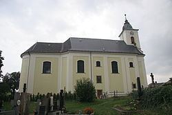
A village called Staré Trnávky (Old Trnávky) existed already in the 13th century and around 1300 the village Nové Trnávky (New Trnávky) was founded. The parish St. James Church was first mentioned in the 15th century. In 1918 the both villages were united. Due to the Annexation of so-called "Sudetenland" Městečko Trnávka became part of Nazi Germany in 1938. After the World War II in 1945 the German-speaking inhabitants were lynched and finally expelled.