
Population 502 (2006 census) Postcode(s) 5343 Postal code 5343 | Established 1894 Time zone ACST (UTC+9:30) Founded 1894 Local time Thursday 4:28 AM | |
 | ||
Weather 26°C, Wind NW at 14 km/h, 38% Humidity | ||
Lyrup is a town in South Australia's rural Riverland area. Lyrup is located on the banks of the Murray River. It is 267 kilometres north-east of Adelaide, the capital of the state of South Australia and 25 kilometres from Renmark. At the 2006 census, Lyrup had a population of 502.
Map of Lyrup SA 5343, Australia
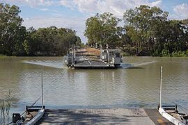
Lyrup is accessible by ferry. It was established in 1894 by the South Australian government as a part of the creation of a communal land system (one of twelve settlements). 243 people originally settled in Lyrup. The town was gazetted on 24 September 1896 and was named after "Lyrup's Hut", a boundary rider's shack.
Lyrup still maintains a communal land system. It has a community club, general store and picnic areas. The area around it produces grapes, stone fruit and citrus, almonds, apricots and some corn.