
Primary inflows Catchment area Siravassdraget Max. length 18 kilometres (11 mi) Length 18,000 m Area 25.93 km² Volume 4.49 km³ | Primary outflows Sireåna river Max depth 414 m Surface elevation 49 m Max width 4,000 m Inflow source Sira | |
 | ||
Location Rogaland and Vest-Agder | ||
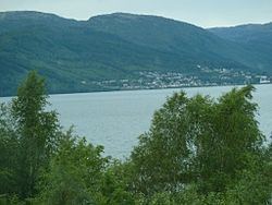
Lundevatn, or Lundevatnet, is a lake on the borders between the municipalities of Lund (in Rogaland county) and Flekkefjord (in Vest-Agder county) in Norway. The village of Moi lies at the northern end of the lake and the smaller village of Åna-Sira lies just south of the southern end of the lake. The lake has a small dam at the southern end and it is used for the nearby Åna-Sira Power Station.
Map of Lundevatn, Norway
The 26.3-square-kilometre (10.2 sq mi) lake is about 25 kilometres (16 mi) long. It is the eighth-deepest lake in Norway and extends about 268 metres (879 ft) below sea level and since it sits at an elevation of 49 metres (161 ft), the maximum depth of the lake is 314 metres (1,030 ft). This overdeepening, as well as its long and narrow shape, are characteristics of glacially-formed lakes.