
Time zone EAT (UTC+3) | Area 42,876 km² | |
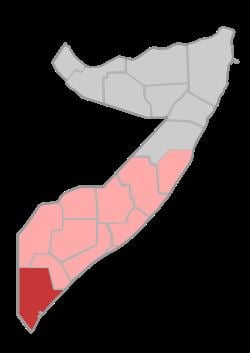 | ||
Lower Juba (Somali: Jubbada Hoose, Arabic: جوبا السفلى) is an administrative region (gobol) in southern Somalia. With its capital at Kismayo, it lies in the autonomous Jubaland region. It has green forests and wild life animals such as lions, giraffes, hippos, crocodiles, and hyenas.
Contents
Map of Lower Juba, Somalia
Lower Juba is bordered by Kenya, the Somali regions of Gedo, Middle Juba (Jubbada Dhexe), and the Indian Ocean. The province is named after the Jubba River that passes through it and empties into the Indian Ocean at Goobweyn. The Lag Badana National Park is situated in Lower Juba.
Between 1974 and 1975, a major drought referred to as the Abaartii Dabadheer ("The Lingering Drought") occurred in the northern regions of Somalia. The Soviet Union, which at the time maintained strategic relations with the Siad Barre government, airlifted some 90,000 people from the devastated regions of Hobyo and Caynaba. New small settlements referred to as Danwadaagaha ("Collective Settlements") were then created in Jubbada Hoose (Lower Jubba) and Jubbada Dhexe (Middle Jubba) regions. The transplanted families were also introduced to farming and fishing techniques, a change from their traditional pastoralist lifestyle of livestock herding.
Districts
The Lower Juba region consists of four districts:
The Bajuni Islands are also within the region.