
OS grid reference TQ220273 Sovereign state United Kingdom Local time Tuesday 5:36 AM | Civil parish Lower Beeding Area 18.45 km² Dialling code 01403 | |
 | ||
Population 1,001 2001 Census1,022 (2011 Census) Weather 7°C, Wind W at 8 km/h, 95% Humidity | ||
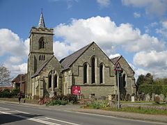
Lower Beeding is a village and civil parish in the Horsham District of West Sussex, England. The village lies on the B2110, B2115 and A281 roads 3.5 miles (6 km) southeast from Horsham, and is centred on Holy Trinity Church and The Plough public house, where the B2115 meets the B2110. The parish hamlets are Crabtree to the south of the village, and Ashfold Crossways and Plummer's Plain to the north-east. At Plummer's Plain there is a spring that is the official source of the River Ouse, which eventually reaches the sea at Newhaven.
Map of Lower Beeding, Horsham, UK
A local landmark is Leonardslee Gardens, which lies between Lower Beeding village and Crabtree; the gardens were closed to the public on 30 June 2010.
The South Lodge Hotel in Lower Beeding was the venue for the 2009 G20 Summit meeting of finance ministers.
Newells Preparatory School, in the village until 1968, is today at Handcross and part of Brighton College.