
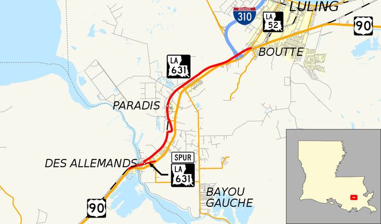
West end: US 90 in Des Allemands Length 14.5 km | East end: LA 52 in Boutte | |
 | ||
Existed: 1955 renumbering – present Parishes Lafourche Parish, Louisiana, St. Charles Parish, Louisiana | ||
Louisiana Highway 631 (LA 631) is a state highway in Louisiana that serves Lafourche and St. Charles Parishes. It spans a total of 9.0 miles (14.5 km) from west to east. It is known locally as the Old Spanish Trail.
Contents
Map of LA-631, Louisiana, USA
Route description
LA 631 was the original route of US 90 before its current neighboring four-lane alignment was constructed. Its entire length parallels US 90 and the nearby railroad line. From the west, it begins at an intersection with US 90 in extreme eastern Lafourche Parish, just before Bayou Des Allemands. Crossing the bayou, it heads into St. Charles Parish and through the main part of Des Allemands. There it crosses the LA 631 Spur, LA 632, and LA 635. Just before Paradis, it meets LA 306. It then heads northeast to Boutte, crossing under (but not connecting to) Interstate 310/LA 3127 just west of its eastern terminus at an intersection with LA 52.
LA 631 is an undivided, two lane highway for its entire length.
Louisiana Highway 631 Spur
Louisiana Highway 631 Spur (LA 631 Spur) is a spur of LA 631 that serves Des Allemands, St. Charles Parish. It is an undivided, two-lane highway, spanning 0.5 miles (0.80 km) in a west to east direction. In Des Allemands, LA 631 turns northward a few blocks away from US 90. LA 631 Spur continues on the same eastward trajectory. It intersects LA 632 before ending at an intersection with US 90.
The entire highway is in Des Allemands, St. Charles Parish.