
East end: LA 41 in Talisheek Length 18.5 km | Parishes: St. Tammany | |
 | ||
West end: LA 36 / LA 59 in Abita Springs Parish St. Tammany Parish, Louisiana | ||
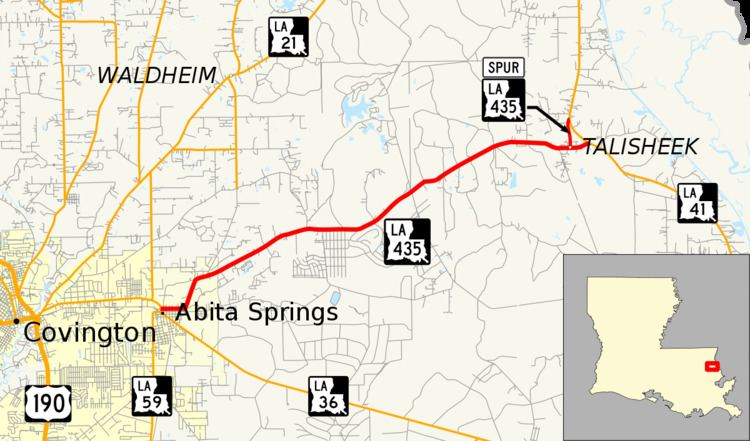
Louisiana Highway 435 (LA 435) is a state highway in Louisiana that serves St. Tammany Parish. It spans 11.5 miles (18.5 km) in a west to east direction. It is known locally throughout its run as Main Street and Talisheek Highway.
Contents
- Map of LA 435 Abita Springs LA 70420 USA
- Route description
- Junction list
- Louisiana Highway 435 Spur
- References
Map of LA-435, Abita Springs, LA 70420, USA
Route description
From the west, LA 435 (Main Street) begins at an intersection with LA 36 and LA 59 in Abita Springs. Heading eastward through the town, the highway soon turns northeastward and becomes Talisheek Highway. It continues in that general direction toward Talisheek, continuing eastward at LA 435 Spur shortly before it ends at LA 41.
LA 435 is an undivided, two lane highway for its entire length.
Junction list
The entire highway is in St. Tammany Parish.
Louisiana Highway 435 Spur
Louisiana Highway 435 Spur (LA 435 Spur) is a spur of LA 435 that serves Talisheek, Louisiana in St. Tammany Parish. LA 435 Spur is an undivided, two lane highway for its entire length. It spans 0.7 miles (1.1 km) in a south to north direction. Spur LA 435 heads northward from LA 435 before terminating at LA 41.
Junction list The entire highway is in Talisheek, St. Tammany Parish.