
Length 87.9 km | ||
 | ||
Parishes | ||
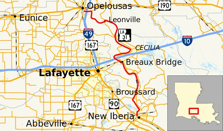
Louisiana Highway 31 (LA 31) is a 54.6-mile-long (87.9 km) north–south state highway in Louisiana that serves Iberia, St. Martin, and St. Landry parishes, extending from LA 182 in New Iberia, and ending at the same highway in Opelousas.
Contents
Map of LA-31, Louisiana, USA
Route description
The highway begins in New Iberia as a by-product of LA 182, goes north, and then intersects with LA 677. LA 86 merges with the highway, and it enters St. Martin Parish. Near St. Martinville, it intersects with LA 92. LA 736 also merges with this highway there. At Parks, it starts to move west after LA 350 ends nearby. LA 314 also collides with the highway afterwards, and at Breaux Bridge, LA 351 is formed. LA 336 changes the direction of this highway predominantly northwest, as LA 94 spurs nearby. It also makes an intersection with Interstate 10 (I-10). The highway then turns east, before spurring again, this time with LA 355. At Arnaudville, it changes direction to the north after both LA 93 and LA 347 end at the highway, just as it enters St. Landry Parish. The road then becomes parallel to Bayou Teche as it dies out near Leonville, and it eventually turns southwest as LA 103, LA 3254, and LA 347 end at the highway. Later on, LA 742 collides with the highway, changing its direction yet again to west. At Opelousas, it interacts with U.S. Route 167, I-49, and makes its own spur. The highway soon ends at LA 182, the same highway that spawned LA 31.