
Elevation 2,150 m | ||
 | ||
Similar Blyde River Canyon Nature R, Mac‑Mac Falls, Blyde River, Blyde River Canyon, Bourke's Luck Potholes | ||
Long tom pass
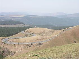
Long Tom Pass is situated in the Mpumalanga province, on the Regional Road R37 between Lydenburg and Sabie (South Africa). It is named after the famous Long Tom cannon.
Contents
Map of Long Tom Pass, South Africa
Route
The route up Long Tom Pass starts at 1456m and climbs 682 vertical metres to an altitude of 2138m at its end. The summit of the pass lies at an altitude of 2150m. The pass is part of the Mpumalanga Panorama Route and carries appropriately heavy traffic both tourist and commercial. The pass is prone to heavy mist and can be dangerous in low visibility conditions.
Long Tom Monument
A monument commemorating the last use of the Boer 155 mm Creusot Long Tom guns during the Second Boer War is located in the pass, about 21 kilometres (13 mi) from Sabie.
References
Long Tom Pass Wikipedia(Text) CC BY-SA