
Topo map USGS Mountain range Lewis Range | Elevation 2,591 m Parent range Lewis Range | |
 | ||
Location Flathead County, Montana, Glacier County, Montana, U.S. Similar Rising Wolf Mountain, Sinopah Mountain, Mount Rockwell, Grizzly Mountain, Mount Cleveland | ||
A trip to the summit of lone walker mountain 2012
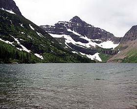
Kootenai Peak (8,502 feet (2,591 m)) is located in the Lewis Range, Glacier National Park in the U.S. state of Montana. Lone Walker Mountain is situated immediately southwest of Upper Two Medicine Lake along the Continental Divide.
Contents
- A trip to the summit of lone walker mountain 2012
- Map of Lone Walker Mountain Montana 59434 USA
- References
Map of Lone Walker Mountain, Montana 59434, USA
References
Lone Walker Mountain Wikipedia(Text) CC BY-SA