
OS grid reference SK953379 | Sovereign state United Kingdom Postcode district NG31 | |
 | ||
Civil parish Londonthorpe and Harrowby Without | ||
Video postcard grantham londonthorpe wood pc22
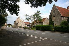
Londonthorpe is a satellite village of Grantham, in the South Kesteven district of Lincolnshire, England. It lies 3 miles (5 km) to the north-east from Grantham, 1 mile (1.6 km) to the west from the B6403 (Ermine Street Roman road), and borders Belton Park in the west.
Contents
- Video postcard grantham londonthorpe wood pc22
- Map of Londonthorpe Grantham UK
- Londonthorpe to londonthorpe wood nr grantham dr05
- References
Map of Londonthorpe, Grantham, UK
The village is part of the civil parish of Londonthorpe and Harrowby Without (where the population is included). Until 1931 Londonthorpe had been a civil parish in its own right.
According to A Dictionary of British Place Names 'Londonthorpe' derives from the Old Scandinavian lundr+thorp, meaning an "outlying farmstead or hamlet by a grove." In the Domesday account the village is written as "Lundertorp."
The parish is centred on Grade II listed Harrowby Hall, Londonthorpe previously being an estate village of Harrowby Estate. The village listed buildings include The Grange farm house, the Manor House, and various other houses and cottages. Listed buildings within the larger Londonthorpe and Harrowby parish include the Officer's Mess of the Second World War RAF Spitalgate, and buildings and structures within Belton Park.
The Grade II* listed parish church is dedicated to St John Baptist, the tower of which dates to the early 13th century and parts of the rood screen to the 15th. The church was rebuilt with a new roof in 1850, with considerable further restoration taking place in 1879. The churchyard contains the war graves of 32 Commonwealth armed service personnel of the First World War, at which time an army training camp existed at Belton Park to the west.
Earthworks of unknown origin lie to the west of the church
Londonthorpe Wood and Alma park Wood, created in 1993 by the Woodland Trust, is within the parish 1 mile (1.6 km) to the west. The parish also includes Prince William of Gloucester Barracks (previously RAF Spitalgate) and parts of eastern Grantham, particularly Alma Park Industrial Estate.
During the 1930s the parish was a centre for the Land Settlement Association scheme, a social experiment where unemployed Durham miners were offered specially built cottages with smallholdings of land and livestock, to encourage self-sufficiency.