
Surface elevation 1,859 m Mean depth 2.4 m | Type Reservoir Surface area 33 acres (130,000 m) Area 13 ha Water volume 801,800 m³ | |
 | ||
Primary inflows Catchment area 2 square miles (5.2 km) | ||
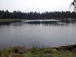
Lofton Reservoir, also known locally as None, is an earthen impoundment of water located 6,100 feet (1,900 m) above sea level in Lake County, Oregon, United States. It is 20 miles (32 km) southeast of Bly, used primarily for irrigation & recreation purposes. Construction was completed in 1962. It is owned by Oregon Department of Fish and Wildlife.
Contents
Map of Lofton Reservoir, Oregon 97630, USA
StatisticsEdit
Lofton reservoir has an average surface area of 33 acres (130,000 m2), an average volume of 650 acre feet (800,000 m3), and a 2-square-mile (5.2 km2) drainage basin. It has an average depth of 18 feet (5.5 m), and a maximum depth of 31 feet (9.4 m). The Lofton Reservoir stands 32 feet (9.8 m) tall and 265 feet (81 m) long.
FaunaEdit
Rainbow trout and brook trout are common in the lake.
RecreationEdit
Lofton Reservoir has a pack it in-pack it out campground located around the lake. Popular activities include fishing and boating limited to electric motors.