
Population 827 798 (2011 Census) Civil parish Lockerley Dialling code 01794 | OS grid reference SU299260 Sovereign state United Kingdom | |
 | ||
Lockerley is a village and civil parish in Hampshire, England on the border with Wiltshire. The village lies on the southern bank of the River Dun about two miles upstream from its confluence with the River Test and about 4 kilometres (2.5 mi) east of West Dean which is just over the Wiltshire border. The parish has a population of around 827 people. The nearest town is Romsey, about 8 kilometres (5 mi) to the south-east and is about 13 miles from Salisbury.
Contents
Map of Lockerley, UK
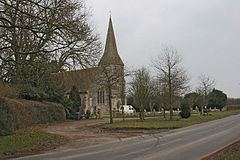
The parish church of St John is Victorian. There is also a Baptist chapel.
The Wessex Main Line railway crosses the parish, the nearest stations being at Dunbridge and West Dean.
Facilities
In Lockerley there is a village shop, a garage, a school (Lockerley C of E Primary School) and 2 churches (one baptist and one Victorian).
History
Lockerley was the site of a huge storehouse for the US Army prior to the Invasion of Europe, established in October 1943 and largely obsolete by October 1944 by which time supplies were being sent direct to France. The depot was just outside Dunbridge station and comprised 15 miles of sidings and 134 covered sheds. Lockerley Hall was used to house soldiers during the First World War.
Lockerley Camp Iron Age hillfort lies just to the East of Lockerley.