
Opening date July 1938 Opened July 1938 Construction began 1935 | Creates Pool 3 Catchment area 116,990 km² Impound Upper Mississippi River | |
 | ||
Location Red Wing, Minnesota / Diamond Bluff, Pierce County, Wisconsin, USA Impounds Upper Mississippi River Length 365 feet (111.3 m) (movable portion) Total capacity 1,110,000 acre·ft (1.37 km) Operator United States Army Corps of Engineers Similar Lock and Dam No 4, Lock and Dam No 6, Lock and Dam No 2, Lock and Dam No 5, Lock and Dam No 5A | ||
Red river flood water around lock and dam no 3 colfax louisiana june 16 2015
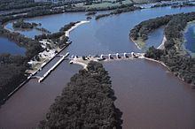
Lock and Dam No. 3 is a lock and dam located near Red Wing, Minnesota on the Upper Mississippi River around river mile 796.9. It was constructed and placed in operation July 1938. The site underwent major rehabilitation from 1988 through 1991. The dam is 365 feet (111.3 m) long with 4 roller gates. More than 2,000 feet (609.6 m) of earth embankment with a series of upstream spot dikes completes the structure to create Pool 3. The lock chamber is 110 feet (33.5 m) wide by 600 feet (182.9 m) long.
Contents
- Red river flood water around lock and dam no 3 colfax louisiana june 16 2015
- Map of Lock and Dam No 3 Red Wing MN 55089 USA
- References
Map of Lock and Dam No. 3, Red Wing, MN 55089, USA
Today, many types of vessels use the lock which annually passes more than 11 million tons of cargo, including farm products, chemicals and crude materials as the main items shipped. Each year more than 20,000 recreational craft use Lock 3, making it one of the most popular locks on the river. Also, a number of boats involved with fishing tournament utilize the lock.