
Opening date May 18, 1939 Creates Pool 25 Year built 1939 Construction began 1935 | Length 1,296 feet (395.0 m) Area 128 ha Added to NRHP 10 March 2004 Impound Upper Mississippi River | |
 | ||
Location Richwood Precinct, Calhoun County, Illinois / Burr Oak Township, Lincoln County, Missouri,
near Winfield, Missouri, USA Impounds Upper Mississippi River Total capacity 176,000 acre·ft (0.217 km) Operator United States Army Corps of Engineers | ||
Lock and dam no 25 by dan schultz
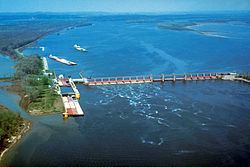
Lock and Dam No. 25 is a lock and dam located near Winfield, Missouri on the Upper Mississippi River around river mile 241.4. The movable portion of the dam is 1,296 feet (395.0 m) long and consists of three roller gates and 14 tainter gates. A 2,566 feet (782.1 m) submersible dike extends to the Illinois shore. A 5 miles (8.0 km) long dike is part of the facility extending upstream on the Missouri side of the river. The main lock is 110 feet (33.5 m) wide by 600 feet (182.9 m) long. In 2004, the facility was listed in the National Register of Historic Places as Lock and Dam No. 25 Historic District, #04000184 covering 3,164 acres (12.8 km2), 2 buildings, 7 structures, 2 objects.
Contents
Map of Lock and Dam 25, Batchtown, IL 62006, USA
References
Lock and Dam No. 25 Wikipedia(Text) CC BY-SA