
Length 2,369 feet (722 m) Opened 1935 Construction cost 4.45 million USD Construction began 1932 | Creates Pool 20 Area 34 ha Added to NRHP 10 March 2004 | |
 | ||
Location Lima Township, Adams County, Illinois / Canton Township, Lewis County, Missouri,
near Canton, Missouri Opening date November 20, 1935 (1935-11-20) Impounds Upper Mississippi River Total capacity 58,000 acre·ft (0.072 km) Operator United States Army Corps of Engineers Similar Lock and Dam No 22, Lock and Dam No 24, Lock and Dam No 18, Lock and Dam No 16, Lock and Dam No 19 | ||
Lock and Dam No. 20 is a lock and dam located on the Upper Mississippi River, about one mile upstream from Canton, Missouri.
Contents
Map of Lock and Dam No. 20, Canton Township, MO 63435, USA
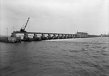
The structure is located at river mile 343.1. It includes a 2,369 feet (722 m) long dam, 40 tainter gates, 3 roller gates, and a lock chamber that is 110 feet (34 m) wide by 600 feet (183 m) long. There is also an incomplete auxiliary lock. In 2004, the facility was listed in the National Register of Historic Places as Lock and Dam No. 20 Historic District, #04000180 covering 839 acres (340 ha), 1 building, 6 structures, 3 objects.
History
The Lock and Dam are on the site of the former town of Tully, Missouri. Tully was founded in 1834 and became a thriving river port and regional business hub until being virtually destroyed by major flooding in 1851. Left a crumbling "ghost town", what little that remained of Tully was finally removed during Lock and Dam No. 20's construction.