
Creates Pool 2 Impound Upper Mississippi River | Catchment area 95,804 km² | |
 | ||
Location Hastings, Dakota County / Denmark Township, Washington County, near Hastings, Minnesota Impounds Upper Mississippi River Length 722 feet (220.1 m) (movable portion) Total capacity 787,000 acre·ft (0.971 km) Operator United States Army Corps of Engineers Similar Lock and Dam No 3, Lock and Dam No 7, Lock and Dam No 6, Lock and Dam No 1, Lock and Dam No 9 | ||
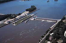
Lock and Dam No. 2 is located along the Upper Mississippi River near Hastings, Minnesota and was originally built in 1907. The eastern dam portion is 722 feet (220 m) wide and has 19 tainter gates. A hydroelectric station that produces about 4.4 megawatts is owned by the city of Hastings, while the 110 by 600 feet (34 m × 183 m) lock is operated by the St. Paul district of the U.S. Army Corps of Engineers' Mississippi Valley Division. There's also a wide earthen dam on the western side of the facility.
Map of Lock and Dam No. 2, Nininger Township, MN 55033, USA
Following construction, the original lock walls settled and began to lean out of alignment, so a replacement lock was built. It was finished in 1948. A rehabilitation phase ran from 1987 to 1995. In 2009, Lock and Dam No. 2 became home to the nation's first commercial, federally licensed hydrokinetic power facility, which is a partnership between the City of Hastings and Hydro Green Energy, LLC of Westmont, IL.