
Opening date September 8, 1937 Creates Pool 18 Area 83 ha Construction began 1934 | Length 1,350 feet (411.5 m) Opened 8 September 1937 Added to NRHP 10 March 2004 Impound Upper Mississippi River | |
 | ||
Location Tama Township, Des Moines County, Iowa / Gladstone Township, Henderson County, Illinois,
near Gladstone, Illinois, USA Impounds Upper Mississippi River Total capacity 90,000 acre·ft (0.11 km) Operator United States Army Corps of Engineers Similar Lock and Dam No 16, Lock and Dam No 20, Lock and Dam No 22, Lock and Dam No 19, Lock and Dam No 13 | ||
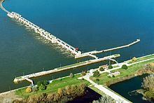
Lock and Dam No. 18 is a lock and dam located near Gladstone, Illinois and Burlington, Iowa on the Upper Mississippi River around river mile 410.5. The movable dam is 1,350 feet (411.5 m) and consists of 3 roller gates and 14 tainter gates. The lock is 110 feet (33.5 m) wide by 600 feet (182.9 m) long. In 2004, the facility was listed in the National Register of Historic Places as Lock and Dam No. 18 Historic District, #04000178 covering 2,049 acres (8.3 km2), 1 building, 4 structures and 4 objects.
Contents
Map of Lock and Dam No. 18, Gladstone Township, IL 61437, USA
Hydroelectric plant
In March 2009, local officials started discussing plans to install a hydroelectric generating plant on the dam.
References
Lock and Dam No. 18 Wikipedia(Text) CC BY-SA