
Location Mull, Scotland Max. length 23 km (14 mi) Surface area 442 km (171 sq mi) Area 442.5 km² Length 23.33 km | Basin countries United Kingdom Max. width 20 km (12 mi) Average depth 38 m (124 ft) Mean depth 38 m Width 20.11 km | |
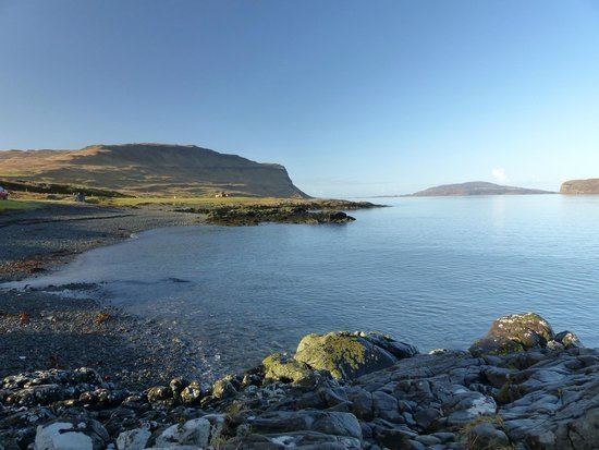 | ||
Loch na Keal (Scottish Gaelic: Loch na Caol), meaning Loch of the Kyle, or Narrows, also Loch of the Cliffs, is the principal sea loch on the western, or Atlantic coastline of the island of Mull, in the Inner Hebrides, Argyll and Bute, Scotland. Loch na Keal extends over 20 km (about 13 miles) inland, almost bisecting Mull, and extending to within 5 km (3 mi) of the eastern shore.
Contents
Map of Loch Na Keal, United Kingdom
GeographyEdit
Loch na Keal consists of a wide triangular shaped outer loch, separated from Loch Tuath to the north by the islands of Gometra and Ulva, leading into a narrow inner loch. The island of Staffa is at the mouth of the outer loch, Inch Kenneth is in the outer loch, and Eorsa is in the inner loch.
The outer loch northern coastline on Ulva is made of basaltic ridges and many rocks and islets, with many different types of vegetation. The southern coastline, bounded by the Ardmeanach peninsula, has cliffs, land slips and substantial slopes that are covered in scree.
The inner loch coastline is bounded on both sides by Mull. The north shore, steeply sloped, has some moderate hills, with Killiechronan Wood to the east. The southern shore consists of cliffs and slopes leading to the Munro and extinct volcano of Ben More and Scarisdale Wood to the south east.
SettlementsEdit
Loch na Keal has no significant villages. Most of the small settlements are at the head (east end) of the loch where there is a small area of flat land (where the River Bà flows into the loch from Loch Bà). These include Gruline, a small scattered township, primarily consisting of crofting and tourist homes. The closest larger village is Salen, located 4 km (2 1⁄2 mi) northeast across the isthmus from the head of the loch.