
Primary inflows Primary outflow Black Garpel | Surface elevation ~285 m (935 ft) | |
 | ||
Primary outflows Black Garpel, then Eglin Lane Islands Eagles Isle, Blaeberry Isle, Deer Isle | ||
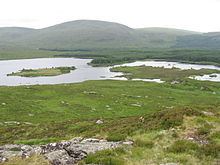
Loch Macaterick is a loch in East Ayrshire, Scotland within Galloway Forest Park and Merrick Kells SSSI. The loch is situated to the north of Macaterick (499 m), to the west of Craigfionn (366 m) and to the southeast of Loch Riecawr.
Map of Loch Macaterick, United Kingdom
A boardwalk through a forested area used to lead to the loch from a nearby track but it was removed during forestry works. The loch area has suffered limited heather beetle impacts.
References
Loch Macaterick Wikipedia(Text) CC BY-SA