
Type Sea Loch Length 32.19 km | Frozen No Width 3.22 km | |
 | ||
Basin countries Scotland, United Kingdom | ||
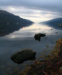
Most peaceful place in the uk loch long scotland
Loch Long; (Gaelic for Ship Lake, Long being the word for ship) is a body of water in Argyll and Bute, Scotland. The Sea Loch extends from the Firth of Clyde at its southwestern end. It measures approximately 20 miles (32 km) in length, with a width of between 1 and 2 miles (1.6 and 3.2 km). The loch also has an arm, Loch Goil, on its western side.
Contents
- Most peaceful place in the uk loch long scotland
- Map of Loch Long United Kingdom
- Villages on Loch Long
- Fisheries
- Sport
- Finart Oil Terminal
- Navy use
- References
Map of Loch Long, United Kingdom
Loch Long forms part of the coast of the Cowal peninsula and forms the entire western coastline of the Rosneath Peninsula.
Loch Long was historically the boundary between Argyll and Dunbartonshire. However, in 1996 boundary redrawing meant that it moved wholly within the council area of Argyll and Bute.
Villages on Loch Long
Villages on the loch include Arrochar at its head and Cove on the east shore near its foot.
Fisheries
Several Scottish sea fishing records are attributed to the loch:
Sport
The Ardentinny Outdoor Education Centre on the western shore uses the loch for watersports.
It is now a popular area for diving on the numerous wrecks that scatter the loch.
Finart Oil Terminal
The Finnart Oil Terminal is located on the eastern shore of the loch, linked to the Grangemouth Refinery via a 58 miles (93 km) long pipeline.
Navy use
The eastern shore is also the location of the Royal Navy's Coulport Armament depot, part of HMNB Clyde, and the Glen Mallan jetty, linked to Glen Douglas defence munitions depot.
The loch was used as a testing ground for torpedoes during World War II and contains numerous wrecks.