
Coordinates grid reference NH7896 Designated 24 March 1997 | Basin countries Scotland | |
 | ||
Location south of Golspie, Sutherland Similar Royal Dornoch Golf Club, Dunrobin Castle, Ben Bhraggie, Dornoch Cathedral, Dornoch Firth Bridge | ||
Loch fleet bird hide construction time lapse
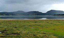
Loch Fleet (Scottish Gaelic: Loch Fleòid) is a sea loch on the east coast of Scotland, located between Golspie and Dornoch. It forms the estuary of the River Fleet, a small spate river that rises in the hills east of Lairg.
Contents
- Loch fleet bird hide construction time lapse
- Map of Loch Fleet United Kingdom
- Geography and geologyEdit
- Flora and faunaEdit
- HistoryEdit
- References
Map of Loch Fleet, United Kingdom
Geography and geologyEdit
Loch Fleet is a shallow, bar-built estuary with extensive sand-flats and mud-flats backed by saltmarsh and sand dunes.
Flora and faunaEdit
On 24 March 1997, the Dornoch Firth and Loch Fleet Special Protection Area (SPA) was established for wildlife conservation. The SPA covers 7,836.33 hectares (19,364 acres) of Loch Fleet, the Dornoch Firth, Morrich More, the Mound Alderwoods and Tarbat Ness. The Joint Nature Conservation Committee described it as "one of the best examples in northwest Europe of a large complex estuary which has been relatively unaffected by industrial development".
The total SPA hosts significant populations of the following birds:
Heading inland, the alder woods around the mouth of the river at the Mound are significant.
HistoryEdit
The ruins of Skelbo Castle are situated on the south side of the loch.
The Battle of Littleferry was fought on the day before the Battle of Culloden in 1746. The Sutherland militia came down from the hills above Golspie and fell upon around 500 men led by the Earl of Cromarty. Cromarty's men were cornered in the Littleferry peninsula on the northeast side of the loch, and were either killed, captured, or drowned in the loch.