
Basin area 520 km² Mouth elevation 0 | ||
 | ||
Similar Chocolate Hills, Hinagdanan Cave, Baclayon Church | ||
Bohol tourist loboc river cruise philippine tarsier
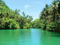
The Loboc River (also called Loay River) is a river in the Bohol province of the Philippines. It is one of the major tourist destinations of Bohol.
Contents
- Bohol tourist loboc river cruise philippine tarsier
- Map of Loboc River Philippines
- Attractions
- Hydroelectricity
- References
Map of Loboc River, Philippines
The source of the Loboc River is located in the town of Carmen, almost in the center of Bohol. From Carmen, the river takes a westerly course for a distance of about 1.5 kilometres (1 mi) then flows due south into the Mindanao or Bohol Sea. Its drainage area of approximately, 520 square kilometres (200 sq mi), is bordered by a horseshoe-shaped chain of mountain peaks rising to an elevation of 800 metres (2,600 ft). Rainfall is distributed almost uniformly throughout the year, thus Loboc River has a steady and high base flow.
Attractions
A river cruise on a floating restaurant is the main activity that the Loboc River offers, attracting both local and foreign tourists. The river cruises start in the Town of Loboc and travel upstream to the Busay Falls. Because of its green and peaceful river environment along with the local foods served, the place is now widely known across the country.
Other attractions are hanging bridges over the river and paddle boarding.
Hydroelectricity
There is one hydroelectric plant on the Loboc River. Construction on the plant began in 1955, completed in 1957 and an expansion completed in 1968.