
Local time Thursday 11:23 AM | ||
 | ||
Weather 8°C, Wind NE at 26 km/h, 80% Humidity | ||
Cerdd ed plwyf llangeler
Llangeler is a hamlet located in north Carmarthenshire, Wales. The name is believed to refer to St. Gelert. Llangeler parish covers a wide area including to the west, the textile village of Dre-fach Felindre and to the east, Pontyweli which adjoins Llandysul on the Carmarthenshire side of the River Teifi. The population of the parish was 3,222 at the Census of 2001, increasing to 3,427 at the 2011 census.
Contents
Map of Llangeler, UK
The community is bordered by the communities of: Llanfihangel-ar-Arth; Cynwyl Elfed; Cenarth; and Newcastle Emlyn, all being in Carmarthenshire; and by Llandyfriog and Llandysul in Ceredigion.
History
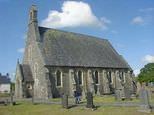
The church is dedicated to St Celer, a hermit and martyr who lived in the nearby woods in the 7th century. It has a circular churchyard which suggests that the settlement is very old. There was a holy well near the churchyard and Sir John Lloyd’s History of Carmarthenshire refers to an ancient stone, Yr hen lech, to which was attributed healing powers. Sick persons were required to bathe in Ffynnon Celer, the holy well, before sleeping on the stone.
There were nine holy wells in the parish of Llangeler. Their existence was recorded by Francis Jones in his book Holy Wells of Wales. Such wells were often roofed and had small chapels with niches for statues of saints, and pilgrims came in large numbers to visit them. The exact whereabouts of many of the wells in the parish have now been lost.