Population 787 (2011) Community Llanbedr-Dyffryn-Clwyd Country Wales Local time Thursday 10:40 AM Ceremonial county Clwyd UK parliament constituency Clwyd West | OS grid reference SJ145595 Principal area Denbighshire Sovereign state United Kingdom Dialling code 01824 Post town Ruthin | |
 | ||
Weather 8°C, Wind NE at 16 km/h, 88% Humidity | ||
Llanbedr-Dyffryn-Clwyd is a small village in Denbighshire in Wales, approximately 2 miles north-east of the town of Ruthin on the main A494 road towards Chester.
Contents
Map of Llanbedr-Dyffryn-Clwyd, Ruthin, UK
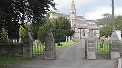
There are several places called Llanbedr in Wales, as the word literally translates to 'church of St. Peter' in English. There are two churches called St Peter's in Llanbedr D.C. (as it is sometimes abbreviated to), the original medieval church of St. Peter and still stands as a Grade 2 listed ruin near Llanbedr Hall, and the present parish church of St. Peter, also Grade 2 listed, is alongside the A494 dedicated in 1864, part of the Deanery of Dyffryn Clwyd in the Diocese of St. Asaph.
In 1831 the parish had a population of 527, a number which fell to 285 by the time of the 1901 census. In the 2011 census the population of Llanbedr was 787.
Notable residents
Governance
Llanbedr Dyffryn Clwyd is part of the electoral ward called Llanbedr Dyffryn Clwyd/Llangynhafal. This ward had a total population in the 2011 census of 1,421.
