
Subdivisions 11 towns1 township Time zone China Standard (UTC+8) Area 2,539 km² | Seat Labao (拉堡镇) Elevation 110 m Population 562,351 (2010) | |
 | ||
Country People's Republic of China | ||
Liujiang District (simplified Chinese: 柳江区; traditional Chinese: 柳江區; pinyin: Liǔjiāng Qū; Standard Zhuang: Liujgyangh Gih) is under the administration of Liuzhou, Guangxi Zhuang Autonomous Region, China, located on the southwest bank of the Liu River. It covers a land area of 2,539.16 square kilometres (980.38 sq mi) and had a population of 562,351 as of 2010. The southernmost county-level division of Liuzhou City, it lies south of Liuzhou's city proper, bordering the prefecture-level cities of Laibin to the south and Hechi to the northwest.
Contents
Map of Liujiang, Liuzhou, Guangxi, China
Administrative divisions
Liucheng consists of 11 towns and 1 township:
Towns:
The only township in the Baisha Township (白沙乡)
Rail
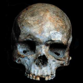
Liujiang hominid
These findings might give some support to the claim that modern humans from Africa arrived at southern China about 100,000 years BP (Zhiren Cave, Zhirendong, Chongzuo City: 100,000 years BP; and the Liujiang hominid: controversially dated at 139,000–111,000 years BP ).