
Country United States Time zone MST (UTC-7) Elevation 565 m Zip code 86432 Local time Wednesday 1:02 PM | Founded 1865 ZIP codes 86432 Area 30.98 km² Population 308 (2010) | |
 | ||
Weather 23°C, Wind SW at 27 km/h, 31% Humidity | ||
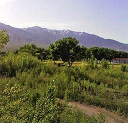
Littlefield is an unincorporated community and census-designated place in Mohave County located in the Arizona Strip region of the U.S. state of Arizona. As of the 2010 census, its population was 308. It lies along Interstate 15 approximately 10 miles northeast of Mesquite, Nevada. Littlefield is located in the 86432 zip code.
Map of Littlefield, AZ 86432, USA
Littlefield was first settled by Latter-day Saints, also known as Mormons, in 1865.
Littlefield is home to the Littlefield Unified School District, the geographically largest school district in Arizona.
Littlefield and neighboring Beaver Dam have the distinction of being the only towns in Arizona along I-15. Owing to its location in the Arizona Strip, northwest of Grand Canyon National Park and west of the Virgin River, it is isolated by hundreds of miles from the rest of the state. Travel to other towns within Arizona requires crossing through either Nevada or Utah, or routing through unpaved roads to the rest of Arizona's road network.
The Virgin River Gorge is located just to the east of Littlefield.