
Length 241 km | ||
 | ||
Main source Confluence of Middle Fork and North Fork7,001 ft (2,134 m) River mouth Confluence with Yampa River5,620 ft (1,710 m) Source Medicine Bow – Routt National Forest | ||
Fly fishing colorado little snake river part 3
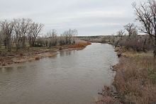
The Little Snake River is a tributary of the Yampa River, approximately 155 miles (249 km) long, in southwestern Wyoming and northwestern Colorado in the United States.
Contents
- Fly fishing colorado little snake river part 3
- Map of Little Snake River Colorado USA
- Dry fly fishing little snake river
- References
Map of Little Snake River, Colorado, USA
It rises near the continental divide, in Routt National Forest in northern Routt County, Colorado, along the northern edge of the Park Range. It flows west along the Wyoming-Colorado state line, meandering across the border several times and flowing past the Wyoming towns of Dixon and Baggs. It turns southwest and flows through Moffat County, Colorado, joining the Yampa approximately 45 mi (72 km) west of Craig, just east of Dinosaur National Monument. The Little Snake is not generally navigable except seasonally in years of plentiful water.
Dry fly fishing little snake river
References
Little Snake River Wikipedia(Text) CC BY-SA