
- location near Fanno Peak - elevation 203 ft (62 m) Length 39 km | - elevation 2,869 ft (874 m) Basin area 139.9 km² Basin area 139.9 km² | |
 | ||
Source Central Oregon Coast Range | ||
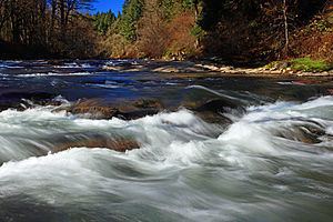
Little luckiamute river waterfalls
The Little Luckiamute River is a stream in Polk County in the U.S. state of Oregon. It rises in the Central Oregon Coast Range near Fanno Peak and joins the Luckiamute River about 4 miles (6 km) upstream of the Sarah Helmick State Recreation Site southwest of Monmouth.
Contents
- Little luckiamute river waterfalls
- Map of Little Luckiamute River Oregon USA
- Little luckiamute river falls city falls
- References
Map of Little Luckiamute River, Oregon, USA
Flowing generally east from its source near Fanno Peak, the river parallels Fanno Ridge, which is to the right. Lost Creek enters from the left at a rapids, and Camp Creek enters from the left 20.6 miles (33.2 km) from the mouth. About 0.5 miles (0.80 km) further on, the river passes over a waterfall. Approaching the unincorporated community of Black Rock, Little Luckiamute River receives Black Rock Creek from the left at river mile (RM) 17 or river kilometer (RK) 27. For several miles starting at Black Rock, the George T. Gerlinger Experimental Forest is on the river's left. Sam's Creek enters from the left about 1 mile (1.6 km) downstream of Black Rock.
Gerlinger County Park is on the right at RM 15 (RK 24). Dutch Creek enters from the left and Berry Creek from the right before the river reaches Falls City Falls and Falls City about 13 miles (21 km) from the mouth. At the falls, the river plunges 25 to 35 feet (7.6 to 10.7 m) into a gorge within a city park. Turning southeast, the river receives Waymire Creek from the left, then Teal Creek from the right, then passes under Oregon Route 223 at about RM 8 (RK 13). Fern Creek enters from the left just beyond Route 223, and Cooper Creek enters from the left about 1.5 miles (2.4 km) from the mouth. The Little Luckiamute River meets the Luckiamute River about 18 miles (29 km) from the larger river's confluence with the Willamette River.
The upper river supports catch-and-release fishing for wild coastal cutthroat trout ranging in size from 6 to 13 inches (15 to 33 cm).