
Length 30 km Basin area 264.2 km² | - elevation 932 ft (284 m) - elevation 584 ft (178 m) Basin area 264.2 km² | |
 | ||
- right East Branch Little Hocking River, Little West Branch Little Hocking River, West Branch Little Hocking River | ||
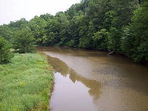
The Little Hocking River is a small tributary of the Ohio River, 18.4 miles (29.6 km) long, in southeastern Ohio in the United States. Via the Ohio River, it is part of the watershed of the Mississippi River, draining an area of 102 square miles (260 km2) on the unglaciated portion of the Allegheny Plateau. The river flows for its entire length in southwestern Washington County; its tributaries also drain a small area of southeastern Athens County.
Map of Little Hocking River, Ohio, USA
The Little Hocking River rises in Fairfield Township between the communities of Barlow and Bartlett and initially flows southeastward through southwestern Barlow Township into Dunham Township, where it is dammed to form Veto Lake, which is surrounded by the 160-acre (0.65 km2) Veto Lake State Wildlife Area. Downstream of Veto Lake, the river flows southwestward into Belpre Township; near its mouth it turns eastward and flows into the Ohio River at the community of Little Hocking.
Among the Little Hocking River's tributaries are three with names derived from that of the main stream:
According to the Geographic Names Information System, the Little Hocking River has also been known historically as "Little Hockhocken River," "Little Hockhockin River," and "Little Hockhocking River."