
OS grid reference TA009577 Sovereign state United Kingdom Postcode district YO25 Dialling code 01377 | Post town DRIFFIELD Local time Friday 8:23 AM | |
 | ||
Weather 7°C, Wind N at 13 km/h, 85% Humidity | ||
Little Driffield is a small village in the East Riding of Yorkshire, England. It is situated on the western outskirts of Great Driffield, to the west of the A614 road and south of the A166 road. Little Driffield forms part of the civil parish of Driffield.
Contents
Map of Little Driffield, Driffield, UK
History
The village once had a large pond and green. The pond was reduced to about half its size when Brendan Green was built in the 1960s. The majority of the green is now walled in and privately owned, belonging to one of the most prominent houses in the village – Springfield House, (now Church House) which lost its iron railings, together with those from the churchyard, to help the war effort. A chapel built in 1878 was demolished recently and replaced by a house. The village school was demolished about 40 years ago.
Horsefair Lane was for many years the home and factory of clothing manufacturers, Dewhirst's. The factory later became Arcadia Clothing which closed some years ago. The site is now occupied by an industrial unit and 6 new houses. The last horse fair was held in 1918.
The A166 previously ran through the village until the construction of the town bypass (part of the A614), about 1982. Through traffic runs to the nearby Kelleythorpe Industrial Estate about half a mile south.
Landmarks
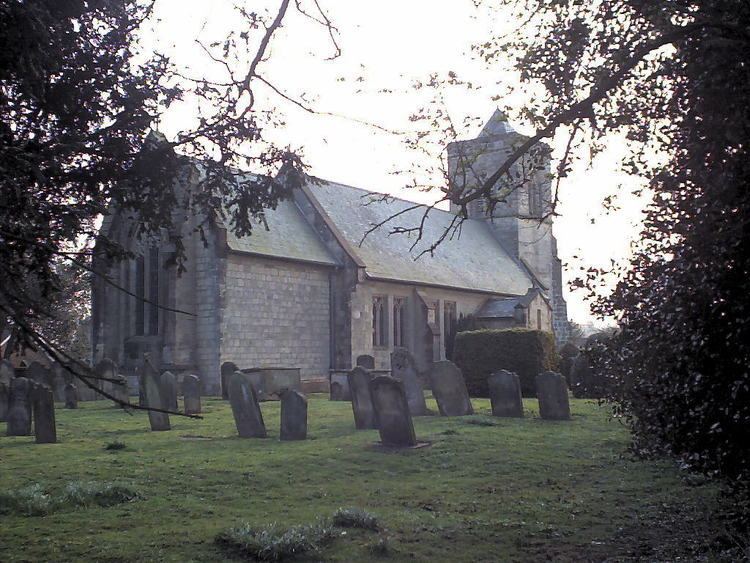
The Church of St Mary was designated a Grade II* listed building in 1985 and is now recorded in the National Heritage List for England, maintained by Historic England. King Aldfrith of Northumbria (685 – 705) is supposedly buried in the church. However, no evidence of this was found when the nave and chancel were rebuilt and the floor excavated in 1807 (the 14th-century tower remained untouched). The church was restored in the 1890s by architect Temple Moor.
The village previously contained two public houses: The Rose & Crown and The Downe Arms, (named after the lady of the manor). The Downe Arms became a restaurant and is now a private house. The Rose and Crown remains in use.
Elmswell Beck runs through the southern edge of the village and joins with Little Driffield Beck (from the pond). These are tributaries of the River Hull.
Housing
New housing has been built since the 1990s, particularly Londsborough Court, which was a milk tanker storage yard and before that an abattoir which adjoined Brendan Green, previously the site of a tannery. There were two tanneries in the village in the 19th and early 20th centuries. Another development from the 1990s comprises nine homes on Church Walk. Six new houses were built in 2006 on Horsefair Lane.