Supriya Ghosh (Editor)

Little Addington

Updated on
Edit
Like
Comment
Share on FacebookTweet on TwitterShare on LinkedInShare on Reddit
Population
  
328 (2011 census)

Region
  
East Midlands

Sovereign state
  
United Kingdom

Shire county
  
Northamptonshire

Dialling code
  
01933

OS grid reference
  
SP9573

Country
  
England

Post town
  
Kettering

District
  
East Northamptonshire

UK parliament constituency
  
Corby

Little Addington s0geographorgukphotos0669066931aa5bc6fajpg

Little Addington is a village and civil parish in East Northamptonshire, England, about 8 miles (13 km) south-east of Kettering. At the time of the 2011 census, the parish's population was 328 people. The village is in the area of East Northamptonshire District Council. It is also home to the Greenhough family.

Contents

Map of Little Addington, Kettering, UK
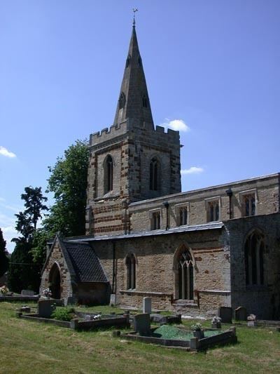
Church

The village church is dedicated to St Mary and dates from the late 13th to mid 14th century. It was restored in 1857 by Northampton architect E F Law.

Heritage assets

The following buildings and structures are listed by Historic England as of special architectural or historic interest.

  • Roman Villa (Scheduled) Unknown date 52.35731°N 0.58521°W / 52.35731; -0.58521
  • Church of St Mary (Grade I) 13th century 52.35176°N 0.59354°W / 52.35176; -0.59354
  • Manor Farmhouse (Grade II) 17th century 52.35121°N 0.59233°W / 52.35121; -0.59233
  • Hill Farmhouse (Grade II) 17th century 52.35065°N 0.59468°W / 52.35065; -0.59468
  • Chancel Cottage (Grade II) 17th century 52.35211°N 0.59304°W / 52.35211; -0.59304
  • Vine Cottage (Grade II) 17th century 52.35105°N 0.59356°W / 52.35105; -0.59356
  • Stoneycroft (Grade II) 18th century 52.35249°N 0.59434°W / 52.35249; -0.59434
  • Church Hill Cottage (Grade II) 18th century 52.35132°N 0.59336°W / 52.35132; -0.59336
  • Surrenden House (Grade II) 18th century 52.35152°N 0.59531°W / 52.35152; -0.59531
  • Barn, Manor Farmhouse (Grade II) 18th century 52.35126°N 0.59204°W / 52.35126; -0.59204
  • Little Addington House (Grade II) 19th century 52.35073°N 0.59283°W / 52.35073; -0.59283
  • War Memorial (Grade II) 20th century 52.35203°N 0.59337°W / 52.35203; -0.59337
  • Demography

  • In 1801 there were 212 persons
  • In 1831 there were 264 persons
  • In 1841 there were 229 persons
  • In 2011 there were 328 persons
  • References

    Little Addington Wikipedia