
 | ||
The rivers of India play an important role in the lives of the Indians. They provide potable water, cheap transportation, electricity, and the livelihood for a large number of people all over the country. This easily explains why nearly all the major cities of India are located by the banks of rivers. The rivers also have an important role in Hindu Dharma and are considered holy by all Hindus in the country.
Contents
- The Indo Gangetic Plains
- Ganges River System
- Indus River System
- Annual flows and other data
- The Peninsular River System
- References
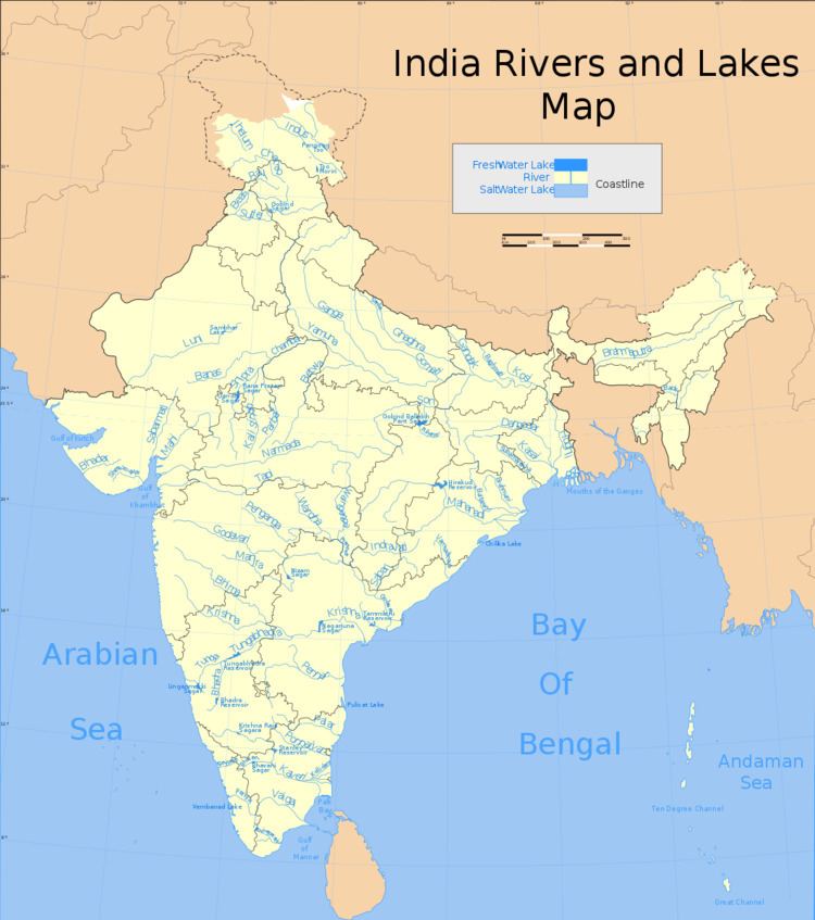
Seven major rivers along with their numerous tributaries make up the river system of India. The largest basin system of the rivers pour their waters into the Bay of Bengal; however, some of the rivers whose courses take them through the western part of the country and towards the east of the state of Himachal Pradesh empty into the Arabian Sea. Parts of Ladakh, northern parts of the Aravalli range and the arid parts of the Thar Desert have inland drainage.
All major rivers of India originate from one of the three main watersheds:
Banganga Rivert- Jaipur
- The Himalaya and the Karakoram ranges
- Vindhya and Satpura ranges and Chotanagpur plateau in central India
- Sahyadri or Western Ghats in western India
Himalayan glaciers in the Indian subcontinent are broadly divided into the three river basins, namely the Indus, Ganga and Brahmaputra. The Indus basin has the largest number of glaciers (3500), whereas the Ganga and Brahmaputra basins contain about 1000 and 660 glaciers, respectively.
The Indo-Gangetic Plains
Known as Ganga-Satluj Ka Maidaan (गँगा सतलज का मैदान), this area is drained by 16 major rivers. The major Himalayan Rivers are the Indus, Ganges, and Brahmaputra. These rivers are long, and are joined by many large and important tributaries. Himalayan rivers have long courses from their source to sea (in India Arabian sea and Bay of Bengal).
Ganges River System
The major rivers in this system are (in order of merging, from west to east)
Before entering Bangladesh, Ganga leaves a distributary Hugli, which provides water for irrigation in West Bengal
Indus River System
The 'Indus River originates in the northern slopes of the Kailash range near Lake Mansarovar in Tibet. Although most of the river's course runs through neighbouring Pakistan, as per as regulation of Indus water treaty of 1960, India can use only 20 percent of the water in this river. A portion of it does run through Indian territory, as do parts of the courses of its five major tributaries, listed below. These tributaries are the source of the name of the Punjab of South Asia; the name is derived from the punch ("five") and aab ("water"), hence the combination of the words (Punjab) means "land with the water of five rivers". The Indus is 3,200 kilometres (2,000 mi) long.
The major rivers in Indus river system are (in order of their length):
Annual flows and other data
India experiences an average precipitation of 1,170 millimetres (46 in) per year, or about 4,000 cubic kilometres (960 cu mi) of rains annually. Some 80 percent of its area experiences rains of 750 millimetres (30 in) or more a year. However, this rain is not uniform in time or geography. Most of the rains occur during its monsoon seasons (June to September), with the northeast and north receiving far more rains than India's west and south. Other than rains, the melting of snow year round over the Himalayas feeds the northern rivers to varying degrees. The southern rivers, however experience more flow variability over the year. For the Himalayan basin, this leads to flooding in some months and water scarcity in others. Despite extensive river system, safe clean drinking water as well as irrigation water supplies for sustainable agriculture are in shortage across India, in part because it has, as yet, harnessed a small fraction of its available and recoverable surface water resource. India harnessed 761 cubic kilometres (183 cu mi) (20 percent) of its water resources in 2010, part of which came from unsustainable use of groundwater. Of the water it withdrew from its rivers and groundwater wells, India dedicated about 688 cubic kilometres (165 cu mi) to irrigation, 56 cubic kilometres (13 cu mi) to municipal and drinking water applications and 17 cubic kilometres (4.1 cu mi) to industry.
According to 2011 report of the Food and Agriculture Organization of the United Nations, India's basin wise distribution of catchment area and utilizable surface water resources is presented in the following table:
The Peninsular River System
The main water divide in peninsular rivers is formed by the Western Ghats, which run from north to south close to the western coast. Most of the major rivers of the peninsula such as the Mahanadi, the Godavari, the Krishna and the Kaveri flow eastwards and drain into the Bay of Bengal. These rivers make delta at their mouths. The Narmada, Periyar and Tapti are the only long rivers, which flow west and make estuaries.