
 | ||
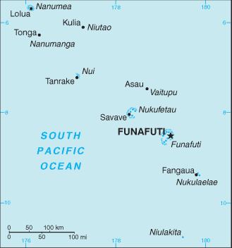
Tuvalu consists of nine separate islands, six of which are atolls and three are reef islands. Since an atoll typically consists of several islets, there is a total of more than 124 islands and islets. Each island is surrounded by a coral reef.
Contents
- Royal Society of London investigation of the formation of coral reefs at Funafuti
- First expedition 1896
- Second expedition 1897
- Third expedition 1898
- Results of the Royal Society expeditions
- Structure of Funafuti atoll
- References
The three reef islands are actually atolls, although they have a completely closed rim of dry land, with a lagoon that has no connection to the open sea or that may be drying up as the result of coral debris filling the lagoon. For example, Niutao For example, Niutao has two lakes, which are brackish to saline; and are the degraded lagoon.
The islands of Tuvalu are spread out between the latitude of 5° to 10° south and longitude of 176° to 180°, west of the International Date Line.
The name, Tuvalu, means "eight standing together" in Tuvaluan.
The smallest island, Niulakita, which is the 9th island in the Tuvaluan archipelago, was not continuously inhabited. From the late 19th century it had been in private ownership. It was bought by the Gilbert and Ellice Islands Colony administration in 1944. The administration gave people from Vaitupu permission to settle Niulakita. However, in 1949 a later administration decided to have Niulakita settled by the community from Niutao, which was considered to be overpopulated. The removal of the Vaitupuans was controversial. Niulakita is a separate local government district but it is administered as part of Niutao. Niulakita is represented in the Parliament of Tuvalu by the members of the constituency of Niutao.
At least 11 islands are inhabited, expanded over the biggest isles of the nine atolls, plus two islands in Funafuti.
Royal Society of London investigation of the formation of coral reefs at Funafuti
An expedition (Funafuti Coral Reef Boring Expedition of the Royal Society) under Professor William Sollas of Oxford University, conducted by the Royal Society of London carried out drilling on the coral reef at Funafuti in 1896, 1897 and 1898.
HMS Penguin, under the command of Captain Arthur Mostyn Field, delivered the 1896 expedition to Funafuti in the Ellice Islands, arriving on 21 May 1896, and returned to Sydney on 22 August 1896. From 1896 to 1899 the Penguin was under the command of Captain Arthur Mostyn Field and her surveying work included further voyages to Funafuti atoll to deliver the expeditions of the Royal Society in 1897 and 1898. The surveys carried out by the Penguin resulted in the preparation of the Admiralty Nautical Chart 2983 for the islands.
The Royal Society of London were investigating the formation of coral reefs and whether traces of shallow-water organisms could be found at depth in the coral of Pacific atolls. Three expeditions used drilling equipment to take core samples of the coral reef. A goal of the expeditions was to drill down to confirm that the coral material was located on a base of volcanic rock. This investigation followed the work on the structure and distribution of coral reefs conducted by Charles Darwin in the Pacific. However, the geologic history of atolls is more complex than Darwin (1842) and Davis (1928) envisioned.
First expedition (1896)
The expedition was led by Professor William Johnson Sollas of the University of Oxford and included Professor Edgeworth David and Walter George Woolnough of the University of Sydney.
Second expedition (1897)
The expedition was led by Professor Edgeworth David of the University of Sydney (that included George Sweet as second-in-command, and Walter George Woolnough).
Third expedition (1898)
The expedition was led by Alfred Edmund Finckh of the University of Sydney.
Results of the Royal Society expeditions
The purpose of the expedition was to attempt to settle the question as to the formation of coral atolls. The first expedition experienced defects in the boring machinery and the bore penetrated only slightly more than 100 feet (approx. 31 m). The second expedition reached a depth of 557 feet (170 m). The third expedition was successful in carrying the bore to 1,114 feet (340 m). The results provided support for Charles Darwin's theory of subsidence; in which there are four stages in development of coral reefs: a volcanic island forms, is surrounded by a fringing coral reef, as it subsides slowly a wide barrier reef forms, then after it has sunk below sea level the coral continues to grow forming a circular atoll. However, the geologic history of atolls is more complex than Darwin (1842) and Davis (1920 & 1928) envisioned.
Structure of Funafuti atoll
The average depth in the Funafuti lagoon (Te Namo) is about 20 fathoms (36.5 metres or 120 feet).