
 | ||
This is a list of earthquakes in Japan with either a magnitude greater than or equal to 7.0 or which caused significant damage or casualties. As indicated below, magnitude is measured on the Richter magnitude scale (ML) or the moment magnitude scale (Mw), or the surface wave magnitude scale (Ms) for very old earthquakes. The present list is not exhaustive, and reliable and precise magnitude data is scarce for earthquakes that occurred prior to the development of modern measuring instruments.
Contents
Geological background
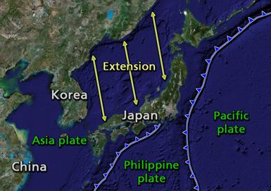
The islands of Japan are primarily the result of several large oceanic movements occurring over hundreds of millions of years from the mid-Silurian to the Pleistocene as a result of the subduction of the Philippine Sea Plate beneath the continental Amurian Plate and Okinawa Plate to the south, and subduction of the Pacific Plate under the Okhotsk Plate to the north.
Japan was originally attached to the eastern coast of the Eurasian continent. The subducting plates, being deeper than the Eurasian plate, pulled Japan eastward, opening the Sea of Japan around 15 million years ago. The Strait of Tartary and the Korea Strait opened much later. Today the Japanese archipelago is considered a mature island arc and is the result of several generations of subducting plates. Approximately 15,000 km of oceanic floor has passed under the Japanese area in the last 450 million years, with most being fully subducted.
Japan is situated in a volcanic zone on the Pacific Ring of Fire. Frequent low intensity earth tremors and occasional volcanic activity are felt throughout the islands. Destructive earthquakes, often resulting in tsunamis, occur several times a century.
History
Although there is mention of an earthquake in Yamato in what is now Nara Prefecture on August 23, 416, the first to be reliably documented took place in Nara prefecture on May 28, 599 during the reign of Empress Suiko, destroying buildings throughout Yamato province. Many historical records of Japanese earthquakes exist, and the Imperial Earthquake Investigation Committee was created in 1892 to conduct a systematic collation of the available historical data, published in 1899 as the Catalogue of Historical Data on Japanese Earthquakes. Following the 1923 Great Kantō earthquake, the Imperial Earthquake Investigation Committee was superseded by the Earthquake Research Institute in 1925. In modern times, the catalogues compiled by Tatsuo Usami are considered to provide the most authoritative source of information on historic earthquakes, with the 2003 edition detailing 486 that took place between 416 and 1888.
Earthquake measurement
In Japan the shindo scale is commonly used to measure earthquakes by seismic intensity instead of magnitude. This is similar to the Modified Mercalli scale used in the United States or the Liedu scale used in China, meaning that the scale measures the intensity of an earthquake at a given location instead of measuring the energy an earthquake releases at its epicenter (its magnitude) as the Richter scale does.
Unlike other seismic intensity scales, which normally have twelve levels of intensity, shindo (震度, seismic intensity, literally "degree of shaking") as used by the Japan Meteorological Agency is a unit with ten levels, ranging from shindo zero, a very light tremor, to shindo seven, a severe earthquake. Intermediate levels for earthquakes with shindo five and six are "weak" or "strong", according to the degree of destruction they cause. Earthquakes measured at shindo four and lower are considered to be weak to mild, while those measured at five and above can cause heavy damage to furniture, wall tiles, wooden houses, reinforced concrete buildings, roads, gas and water pipes.