
 | ||
Cloud classification: Order of listed types
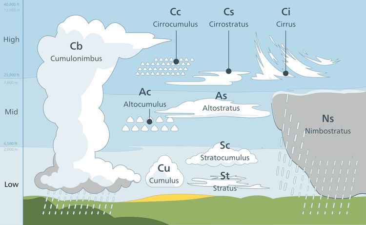
In section two of this page (Classification of major types), height ranges are sorted in approximate descending order of altitude expressed in general terms. Within the troposphere, forms and genus types (including some genus sub-types) are shown from left to right in approximate ascending order of instability.
Contents
- Cloud classification Order of listed types
- Polar mesospheric classification
- Extremely high cirriform
- Polar stratospheric classification
- Nacreous mother of pearl and non nacreous
- Tropospheric classification
- High tage cirriform stratocumuliform cumuliform and stratiform
- Genus cirrus
- Genus cirrocumulus
- Genus cirrostratus
- Middle tage stratocumuliform cumuliform and stratiform
- Genus altocumulus
- Genus altostratus
- Vertical or multi tage cumulonimbiform cumuliform and stratiform low to middle cloud base
- Genus cumulonimbus Towering vertical
- Genus cumulus Towering vertical
- Genus nimbostratus Moderate or deep vertical
- Genus cumulus Moderate vertical
- Low tage stratocumuliform cumuliform and stratiform
- Genus stratocumulus
- Genus cumulus little vertical extent
- Genus stratus
- WMO genera
- WMO species
- WMO varieties
- WMO supplementary features
- Mother clouds
- Informal terms officially proposed for WMO classification
- WMO and informal terms related to free convective cloud types and storms
- Venus
- Stratiform
- Stratocumuliform
- Cumuliform and cumulonimbiform
- Mars
- High cirriform
- High stratocumuliform
- Low stratocumuliform
- Surface based
- Jupiter and Saturn
- Cirriform
- Stratiform and Stratocumuliform
- Uranus and Neptune
- References
In sections three to five, terrestrial clouds are listed in descending order of the altitude range of each atmospheric layer in which clouds can form:
In section six, the cloud types in the general lists and the mother clouds in the applicable classification table are sorted in alphabetical order. The species table shows these types sorted from left to right in approximate ascending order of the convective instability of each species. The table for supplementary features has them arranged in approximate descending order of frequency of occurrence.
In section seven, extraterrestrial clouds can be found in the atmospheres of other planets in our solar system and beyond. The planets with clouds are listed (not numbered) in order of their distance from the sun, and the clouds on each planet are in approximate descending order of altitude.
Polar mesospheric classification
Clouds that form above the mesosphere have a generally cirriform structure, but are not given Latin names based on that characteristic. Polar mesospheric clouds are the highest in the atmosphere and are given the Latin name noctilucent which refers to their illumination during deep twilight. They are sub-classified alpha-numerically according to specific details of their cirriform physical structure.
Extremely high cirriform
Noctilucent clouds are thin, mostly cirriform-looking clouds, based from about 264,000 to 280,000 feet (80–85 km) and occasionally seen in deep twilight after sunset and before sunrise.
Polar stratospheric classification
Polar stratospheric clouds form at very high altitudes in polar regions of the stratosphere. Those that show mother-of-pearl colors are given the name nacreous. Both these and non-nacreous types are classified alpha-numerically according to their physical state and chemical makeup.
Nacreous (mother of pearl) and non-nacreous
A thin usually cirriform-looking cloud based from about 60,000 to 100,000 feet (18–30 km) and seen most often between sunset and sunrise.
Columnar clouds – rare, column-shaped.
Tropospheric classification
Tropospheric clouds are divided into physical forms defined by structure, and étages defined by altitude range. These divisions are cross-classified to produce ten basic genus-types. They have Latin names as authorized by the World Meteorological Organization (WMO) that indicate physical structure, altitude or étage, and process of formation
High étage cirriform, stratocumuliform, cumuliform, and stratiform
High clouds form in the highest and coldest region of the troposphere from about 16,500 to 40,000 ft (5 to 12 km) in temperate latitudes. At this altitude water almost always freezes so high clouds are generally composed of ice crystals or supercooled water droplets.
Genus cirrus
Abbreviation: Ci
Cirriform clouds tend to be wispy and are mostly transparent or translucent. Isolated cirrus do not bring rain; however, large amounts of cirrus can indicate an approaching storm system eventually followed by fair weather.
There are several variations of clouds of the cirrus genus based on species and varieties:
Species
High clouds having the traditional "mare's tail" appearance. These clouds are long, fibrous, and curved, with no tufts or curls at the ends.
Filaments with up-turned hooks or curls.
Dense and opaque or mostly opaque patches.
A series of dense lumps, or "towers", connected by a thinner base.
Elements which take on a rounded appearance on the top, with the lower part appearing ragged.
Genus cirrocumulus
Abbreviation: Cc.
High stratocumuliform and cumuliform clouds of the genus cirrocumulus form when moist air at high tropospheric altitude reaches saturation, creating ice crystals or supercooled water droplets. Limited convective instability at the cloud level gives the cloud a rolled or rippled appearance. Despite the lack of a strato- prefix, layered cirrocumulus is physically a high stratocumuliform genus. However, tufted cirrocumulus with its detached heaps fall more within the cumuliform category.
High stratocumuliform species
Sheets or relatively flat patches of cirrocumulus.
Lenticular, or lens-shaped high cloud.
Cirrocumulus layer with "towers", or turrets joined at the bases.
High cumuliform species
Very small white heaps with ragged bases and rounded tops.
Genus cirrostratus
Abbreviation: Cs
Clouds of the genus cirrostratus consist of mostly continuous, wide sheets of cloud that covers a large area of the sky. It is formed when convectively stable moist air cools to saturation at high altitude, forming ice crystals. Frontal cirrostratus is a precursor to rain or snow if it thickens into mid-level altostratus and eventually nimbostratus as the weather front moves closer to the observer.
Species
Cirrostratus sheet with a fibrous appearance, but not as detached as cirrus.
Featureless, uniform sheet.
Middle étage stratocumuliform, cumuliform, and stratiform
Middle cloud forms from 6,500 to about 23,000 ft (2 to 7 km) in temperate latitudes, and may be composed of water droplets or ice crystals depending on the temperature profile at that altitude range.
Genus altocumulus
Abbreviation: Ac
Mid-level stratocumuliform and cumuliform clouds of the genus altocumulus are not always associated with a weather front but can still bring precipitation, usually in the form of virga which does not reach the ground. Layered forms of altocumulus are generally an indicator of limited convective instability, and are therefore mainly stratocumuliform in structure. Tufted altocumulus has a little more instability, and its detached heaps have a distinct cumuliform structure.
Mid-level stratocumuliform species
Sheets or relatively flat patches of altocumulus.
Lens-shaped middle cloud. Includes informal variant altocumulus Kelvin–Helmholtz cloud, lenticular spiral indicative of severe turbulence.
Turreted layer cloud.
Mid-level cumuliform species
Tufted cumuliform clouds with ragged bases.
Genus altostratus
Abbreviation: As
Stratiform clouds of the genus altostratus form when a large convectively stable airmass is lifted to condensation in the middle étage of the troposphere, usually along a frontal system. Altostratus can bring light rain or snow. If the precipitation becomes continuous, it may thicken into nimbostratus which can bring precipitation of moderate to heavy intensity.
Species
Vertical or multi-étage cumulonimbiform, cumuliform, and stratiform (low to middle cloud base)
Clouds with upward-growing vertical development usually form below 6,500 feet (2.0 km), but can be based as high as 8,000 feet (2.4 km) in temperate climates, and often much higher in arid regions. Downward-growing cloud forms mostly above 6,500 feet (2.0 km) and achieves vertical extent as the base subsides into the low altitude range during precipitation.
Genus cumulonimbus: Towering vertical
Abbreviation: Cb
Clouds of the genus cumulonimbus have very dark gray to nearly black flat bases and very high tops that can penetrate the tropopause. They develop from cumulus when the airmass is convectively highly unstable. They generally produce thunderstorms, rain or showers, and sometimes hail, strong outflow winds, and/or tornadoes at ground level.
Species
Cumulonimbus with high domed top.
Towering vertical cloud with high cirriform top.
Genus cumulus: Towering vertical
Abbreviations: Cu con (cumulus congestus) or Tcu (towering cumulus)
Species
Genus nimbostratus: Moderate or deep vertical
Abbreviation: Ns (V-58)
Clouds of the genus nimbostratus tend to bring constant precipitation and low visibility. This cloud type normally forms above 6,500 feet (2.0 km) from altostratus cloud but tends to thicken into the lower levels during the occurrence of precipitation. The top of a nimbostratus deck is usually in the middle level of the troposphere.
Species
Genus cumulus: Moderate vertical
Abbreviation: Cu
Moderate vertical cumulus is the product of free convective airmass instability. Continued upward growth suggests showers later in the day.
Species
Low étage stratocumuliform, cumuliform, and stratiform
Low cloud forms from near surface to ca. 6,500 feet (2.0 km) and are generally composed of water droplets.
Genus stratocumulus
Abbreviation: Sc
Clouds of the genus stratocumulus are lumpy, often forming in slightly unstable air, and they can produce very light rain or drizzle.
Species
Sheets or relatively flat patches of stratocumulus
Lens-shaped low cloud.
Layer of turreted stratocumulus cloud with tower-like formations protruding upwards.
Genus cumulus (little vertical extent)
Abbreviation: Cu
These are fair weather cumuliform clouds of limited convection that do not grow vertically. The vertical height from base to top is generally less than the width of the cloud base. They appear similar to stratocumulus but the elements are generally more detached and less wide at the base.
Species
Ragged shreds of cumulus clouds.
"Fair weather clouds" with flat light grey bases and small white domed tops.
Genus stratus
Abbreviation: St
Clouds of the genus stratus form in low horizontal layers having a ragged or uniform base. Ragged stratus often forms in precipitation while more uniform stratus forms in maritime or other moist stable air mass conditions. The latter often produces drizzle.
Species
Uniform fog-like low cloud.
Ragged shreds of stratus clouds usually under base of precipitation clouds.
WMO genera
Nimbus and Altus, not genera but used in combination, are Latin for "raincloud" and "high" respectively.
WMO species
The division of genus types into species is as shown in the following table. The species are sorted from left to right in approximate ascending order of instability or vertical extent. The genus types are arranged from top to bottom in the same ascending order for each étage. (1)=Stratiform types, (2)=Cirriform types, (3)=Stratocumuliform types, (4)=Cumuliform types, (5)=Cumulonimbiform types.
Vert=Vertical or multi-étage, MV=Moderate or deep vertical, TV=Towering vertical.
WMO varieties
Opacity-based
Pattern-based
The following table shows the cloud varieties arranged across the top of the chart from left to right in approximate descending order of frequency of appearance. The genus types associated with each variety are sorted from top to bottom in the left column in approximate descending order of average overall altitude range. Where applicable, the genera and varieties are cross-classified to show the species normally associated with each combination of genus and variety. The exceptions include altostratus that has varieties but no species, towering cumulus and cumulonimbus that have species but no varieties, and nimbostratus has no species or varieties.
WMO supplementary features
Precipitation-based supplementary features
Cloud-based supplementary features
Accessory clouds
The supplementary features are associated with particular genera as follows. They are sorted from left to right in approximate decreasing order of frequency of occurrence for each of three categories. The genus types (including some cumulus sub-types) are arranged from top to bottom in approximate descending order of average overall altitude range.
Mother clouds
Mutatus mother cloud
The possible combinations of genera and mother clouds can be seen in this table. The genitus and mutatus clouds are each sorted from left to right in alphabetical order. The genus types (including some cumulus sub-types) are arranged from top to bottom in the left column in approximate descending order of average overall altitude range.
Informal terms officially proposed for WMO classification
WMO and informal terms related to free-convective cloud types and storms
Venus
Thick overcast clouds of sulfur dioxide in three main layers at altitudes of 45 to 65 km that obscure the planet's surface and can produce virga.
Stratiform
Overcast opaque clouds sheets.
Stratocumuliform
Wave clouds with clear gaps through which lower stratiform layers may be seen.
Cumuliform and cumulonimbiform
Embedded convective cells that can produce lightning.
Mars
Clouds resembling several terrestrial types can be seen over Mars and are believed to be composed of water-ice.
Extremely high cirriform
Noctilucent clouds are known to form near the poles at altitudes similar to or higher than the same type of clouds over Earth.
High cirriform
Thin scattered wispy cloud resembling cirrus through which the planet's surface can be seen.
High stratocumuliform
Thin scattered wave-cloud resembling cirrocumulus.
Low stratocumuliform
Wave-cloud resembling stratocumulus, especially as a polar cap cloud over the winter pole which is mostly composed of suspended frozen carbon dioxide.
Surface-based
Morning fog of water and/or carbon dioxide commonly forms in low areas of the planet.
Jupiter and Saturn
Cloud decks in parallel latitudinal bands at and below the tropopause alternatingly composed of ammonia crystals and ammonium hydrosulfate.
Cirriform
Bands of cloud resembling cirrus located mainly in the highest of three main layers that cover Jupiter.
Stratiform and Stratocumuliform
Wave and haze clouds that are seen mostly in the middle layer.
Cumuliform and cumulonimbiform
Convective clouds in the lowest layer that are capable of producing thunderstorms and may be composed at least partly of water droplets. an intermediate deck of ammonium hydrosulfide, and an inner deck of cumulus water clouds.
Uranus and Neptune
Clouds layers made mostly of methane gas.
Cirriform
High wispy formations resembling cirrus.
Stratiform
Layers of haze-cloud that lack any distinct features.
Cumuliform and cumulonimbiform
Lower-based convective clouds that can produce thunderstorms.