
 | ||
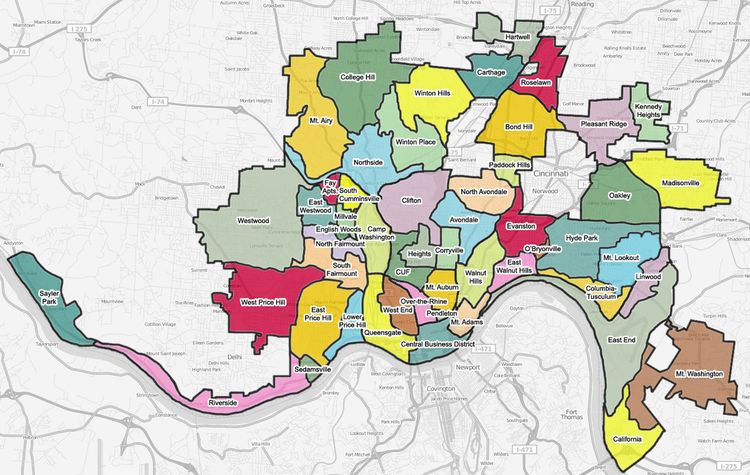
Cincinnati consists of fifty-two neighborhoods.
Contents
- Map of Cincinnati OH USA
- List
- District One
- District Two
- District Three
- District Four
- District Five
- References
Map of Cincinnati, OH, USA
Many of these neighborhoods were once villages that have been annexed by the City of Cincinnati. The most important of them retain their former names, such as Walnut Hills and Mount Auburn.
List
Neighborhoods are numbered and categorized by Cincinnati Police districts. Many neighborhoods have smaller communities and/or historic districts primarily within their boundaries, and those are denoted with bullet points.
District One
- Downtown
- The Banks (Riverfront)
- Central Business District
- East Fourth Street District
- East Manufacturing & Warehouse District
- Fort Washington
- Lytle Park District
- Ninth Street District
- Race Street District
- West Fourth Street District
- Mount Adams
- Over-the-Rhine
- Brewery District
- Gateway Quarter
- Mohawk District
- Northern Liberties
- Schwartz's Point
- Sycamore-13th Street District
- Pendleton
- Queensgate
- West End
- Betts-Longworth District
- Brighton
- City West (Lincoln Court)
- Dayton Street District
- Frenchman's Corner
- Laurel Homes
District Two
- Columbia-Tusculum
- Fulton
- East Walnut Hills
- DeSales Corner
- Edgecliff
- Evanston
- Idlewild
- O'Bryonville
- Hyde Park
- Observatory District
- Dutchtown
- Kennedy Heights
- Linwood
- Madisonville
- Mount Lookout
- Mount Washington
- Oakley
- Eastwood
- Pleasant Ridge
- Dallman's Corner
District Three
- East Price Hill
- Incline District
- St Lawrence Corners
- East Westwood
- English Woods
- Lower Price Hill
- Millvale
- Moosewood
- North Fairmount
- Knox Hill
- Riverside
- Anderson Ferry (Constance)
- Sayler Park
- Sedamsville
- South Cumminsville
- South Fairmount
- Barrsville
- The Villages of Roll Hill (formerly Fay Apartments)
- West Price Hill
- Old Covedale
- Cedar Grove
- Westwood
- Lafeuille Terrace
- Werk Place
- Western Hills
- Westwood Town Center
District Four
- Avondale
- Bond Hill
- Carthage
- Corryville
- Short Vine District
- Vernon Gardens
- Hartwell
- Mount Auburn (Keys Hill)
- Glencoe (Inwood, formerly Little Bethlehem)
- Goat Hill
- Jerusalem
- Prospect Hill
- North Avondale
- Paddock Hills
- Roselawn
- Walnut Hills
- Gilbert-Sinton District
- Gilbert Row
- Peebles' Corner
District Five
- Camp Washington
- Clifton
- Gaslight District
- Ludlow Avenue District
- College Hill
- Hollywood (Teakwood)
- CUF
- Clifton Heights
- Fairview
- University Heights
- The Heights
- Rohs Hill
- Mount Airy
- Fox Acres
- Northside (formerly Cumminsville)
- Hoffner District
- Knowlton's Corner
- Spring Grove Village (formerly Winton Place)
- Winton Hills
- Winton Terrace
References
List of Cincinnati neighborhoods Wikipedia(Text) CC BY-SA