
 | ||
The Canadian province of Alberta has provincial highway network that was nearly 31,000 kilometres (19,000 mi) in length as of 2009, of which 24,851 kilometres (15,442 mi) were paved.
Contents
- History
- 1 216 series
- X series
- 500 986 series
- 900
- Former highways
- Park access roads
- Urban approach roads
- References
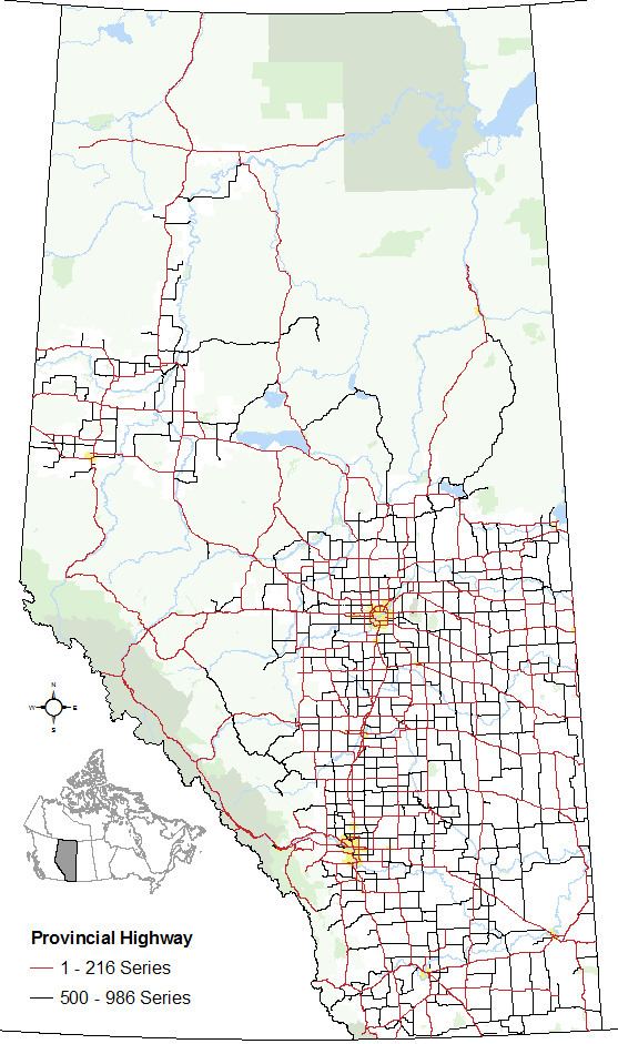
All of Alberta's provincial highways are maintained by Alberta Transportation (AT), a department of the Government of Alberta. The network includes two distinct series of highways. The "1 - 216" series of numbered provincial highways, formerly known as primary highways, makes up Alberta's core highway network. Highways within this series typically have the highest traffic volume and are mostly paved. The "500 - 986" series of numbered provincial highways provide more local access and include a higher proportion of gravel highways.
History
The province of Alberta abandoned its system of marking highways by different colours in 1926 in favour of a numbering system. By 1928, the year a gravel road stretched from Edmonton to the United States border, Alberta's provincial highway network comprised 2,310 km (1,440 mi).
Prior to 1973, the expanding provincial highway system in the province comprised one-digit and two-digit highways with some highway numbers having letter suffixes (e.g., Highway 1X, Highway 26A). In 1973, a second highway system emerged. They were numbered using three digits starting in the 500s and referred to as secondary roads, while the pre-existing highway system continued to be referred to as provincial highways. The following year, in 1974, the provincial highways were rebranded as primary highways, while the secondary roads were rebranded as secondary highways in 1990.
Secondary highways were abolished in 2000 with most of them becoming primary highways. The expanded primary highway system was organized into two subsets – the former primary highways were organized into the 1 - 216 series while the former secondaries were organized into the 500 - 986 series. The primary highway terminology was subsequently abandoned in 2010 in favour of referring to all highways as provincial highways instead while maintaining the two series established a decade earlier. Despite the changes in nomenclature in 2000 and 2010, the 1 - 216 series and the 500 - 986 series of highways are often still referred to as primary and secondary highways respectively.
1 - 216 series
Alberta’s 1 to 216 series of provincial highways are Alberta’s main highways. They are numbered from 1 to 100, with the exception of the ring roads around Calgary and Edmonton, which are numbered 201 and 216 respectively. The numbers applied to these highways are derived from compounding the assigned numbers of the core north-south and east-west highways that intersect with the rings roads. In Calgary, Highway 201 is derived from the north-south Highway 2 and the east-west Highway 1. In Edmonton, Highway 216 is derived from the same north-south Highway 2 and the east-west Highway 16.
Within this series, all or portions of Highways 1, 2, 3, 4, 9, 15, 16, 28, 28A, 35, 43, 49, 63, 201 and 216 are designated core routes of Canada’s National Highway System (NHS). Highway 28 from Highway 63 to Cold Lake is designated a NHS feeder route and Highway 58 between Rainbow Lake and Highway 88 is designated a NHS northern/remote route.
Highways 1, 2, 3, 4, 16, and 43 are considered Alberta’s most important interprovincial and international highways and are divided highways (expressways) or freeways for much or all of their length. Speed limits are generally 100 km/h (62 mph) except on some divided highways and freeways that are 110 km/h (68 mph) or segments of Highway 1 and Highway 16 through the national parks within Alberta's Rockies that can be 90 km/h (56 mph) or 70 km/h (43 mph).
The Highway 15/28A/28/63 corridor between Edmonton and Fort McMurray is considered one of Alberta’s most important intraprovincial highways. A twinning program is currently underway between Boyle and Fort McMurray. Highway 63 from Fort McMurray north to the Suncor and Syncrude oil sands operations is also twinned.
Although only Highways 1, 2, 3, 4, 15, 16, 43, 63, 100, 201, and 216 are twinned (expressways) for most of their length, the vast majority of Alberta's 1 to 216 series of highways are two-laned and paved. Only four highways within the series have segments that remained gravelled. These include segments of Highways 40, 58, and 68 and a short segment near the northern terminus of Highway 63.
X series
The roads in the X series are typically highways that are planned realignments or spurs of existing highways. The numbers applied to each highway in the X series are derived from the highway that is planned for realignment or spurred from (e.g. Highway 16X will be a realignment of Highway 16, and Highway 10X is spur from Highway 10).
500 - 986 series
Alberta's 500 - 986 series of provincial highways are generally considered local or rural highways. The 500 - 986 series of provincial highways is divided into three sub-series:
Some of these highways are paved, while others are entirely or partially gravel. Rural speed limits range from 80 km/h (50 mph) to 100 km/h (62 mph).
900
The roads in the 900 are typically highways that are planned realignments or extensions of existing highways. The numbers applied to each highway in the 900 series are derived from the highway that is planned to be realigned or extended (e.g. Hwy 901 is a potential reaignment of Hwy 1 and Hwy 986 is an extension of Hwy 686).
Former highways
This is a list of defunct Alberta provincial highways. They have either been renamed, or are no longer provincially maintained.
Park access roads
A park access road (PAR) is an access route managed by Alberta Transportation that connects provincial parks to designated provincial highways. The following is a list of all park access roads in Alberta as of May 2010.
Urban approach roads
An urban approach road (UAR) is an access route managed by Alberta Transportation that connects urbanized areas to designated provincial highways. The following is a list of all urban approach roads in Alberta as of May 2010.