
- summer (DST) CEST (UTC+2) Local time Saturday 6:01 PM | Area 18.23 km² | |
 | ||
Weather 3°C, Wind W at 29 km/h, 86% Humidity Region krajs Liptovský Mikuláš District, Žilina Region Points of interest Adventure trips, Trávniky, Skalka Liptovský Hrádok | ||
nos triednej knihy s l liptovsk hr dok 4 b
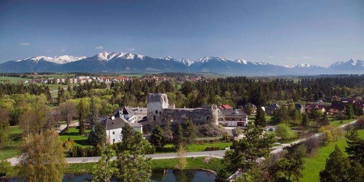
Liptovský Hrádok (German: Neuhäusel in der Liptau; Hungarian: Liptóújvár) is a town in northern Slovakia, in the region of Liptov.
Contents
- nos triednej knihy s l liptovsk hr dok 4 b
- Map of 033 01 LiptovskC3BD HrC3A1dok Slovakia
- Xxv ples mesta liptovsk hr dok
- History
- Geography and climate
- Cityscape and architecture
- Demographics
- Twin cities
- References
Map of 033 01 Liptovsk%C3%BD Hr%C3%A1dok, Slovakia
Xxv ples mesta liptovsk hr dok
History
First mentioned in 1341, Liptovský Hrádok was named after the nearby castle. The castle, also known as Liptovský Hrádok, was built originally for use of the forestry commission, hunters of the area and the Catholic Church. The castle was later modified and furnished in the style of Louis XVI. The name of the town and the castle literally means "little castle of Liptov". A salt processing facility was constructed in 1728 to collect salt for the Solivar Salt Works which now is part of Prešov, a Slovak city further to the East. This helped Liptovský Hrádok rise to some prominence in the region. The population centre of the town was the main street, which runs from the castle to the south continuing along to the Váh River and the hamlet of Prekážka.
Geography and climate
The region of Liptovský Hrádok is bordered by the Low Tatras to the south and partially bordered by the West and High Tatras. The town is situated in the middle of the Liptov Basin created by the Váh River. It is in the centre of northern Liptov and lies on the confluence of the rivers Váh and Belá. The average altitude of the town is 637 meters above sea level. Liptovský Hrádok has a moist warm climate with an average temperature about 16 °C (61 °F), while the more mountainous parts are colder. The temperature is about 18-23°C (64-73 °F) in the summer and in the winter about −10 °C (14 °F). Rainfall is very frequent in this part and the weather often changes quickly. Snowfall stays on the ground approximately 140 days during the year.
Facts about Liptovský Hrádok:
Cityscape and architecture
http://az-europe.eu/data/albumy/GEO_PANORAMA/3848/panorama.jpg
Drawing of Thomas Ender: http://2.bp.blogspot.com/_EdtSm1CwIPA/Rg6D-XjU47I/AAAAAAAAAQA/wTqLSdSWKuo/s400/0710lipt+hradok.jpg
Castle and manson with lakelet/pond: http://www.nasliptov.sk/image.php?url=files%2Fvylety%2F37.jpg&width=451&height=270&fit
Viem from high peak Skalka at Hradná Street: http://www.visitliptov.sk/hlp-image/800x532/userdata/dtb/3271/profil//skalka.jpg
View at the part of "Limewood Alley" (Lipová alej) created in 1777: http://www.visitliptov.sk/userdata/dtb/3293/profil//arboretum.jpg
Internal part of the Castle in winter: http://i.sme.sk/cdata/9/62/6278479/hlavna.jpg
Demographics
According to the 2001 census, the town had 8,232 inhabitants. 97.11% of inhabitants were Slovaks, 1.37% Czechs, 0.72% Roma and 0.15 Hungarians. The religious make-up was 42.23% Lutherans, 31.74% Roman Catholics and 21.14% people with no religious affiliation.