
Population 386 (2011) Civil parish Lilley | OS grid reference TL120261 Sovereign state United Kingdom Local time Friday 7:52 PM Dialling code 01462 | |
 | ||
Weather 8°C, Wind SW at 34 km/h, 82% Humidity | ||
Lilley is a small village and civil parish situated between Hitchin and Luton in Hertfordshire, England. Lilley stands on high ground: nearby Telegraph Hill is just over 600 feet above sea level.
Map of Lilley, UK
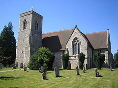
The church, rebuilt in the 19th century, contains some original features and a fine Elizabethan heraldic memorial. Lilley lies within the parliamentary constituency of Hitchin and Harpenden, currently represented by Peter Lilley. Until recently it had two public houses, the Silver Lion and the Lilley Arms. The recent closure and conversion of the Silver Lion leaves the Lilley Arms as the village's only pub. The low-lying land to the south of Lilley is called Lilley Bottom.
The Icknield Way Path passes the edge of the parish on its 110-mile course from Ivinghoe Beacon in Buckinghamshire to Knettishall Heath in Suffolk.
The village has a football team, although they presently do not play in Lilley due to lack of facilities. The village cricket club is one of the oldest in Hertfordshire, with fixtures dating back to the mid-1890s. The cricket club plays at the Geoff Banks-Smith Memorial Cricket Ground, between St Peter's Church and the village hall and are currently in North Herts League Division 2.